Energy News  
Tropical Storm Fay's Center Now Moving Inland

NASA's TRMM spacecraft observed this view of Tropical Storm Fay on August 20, 2008 at 0345Z as it crossed Florida. At this time the storm sustained winds of 45 knots (52 mph) and a pressure reading of 990 millibars. The storm stalled in this location for 24 hours and brought over 24 inches of rain to Eastern Florida. The cloud cover is taken by TRMM's Visible and Infrared Scanner(VIRS) and the GOES spacecraft. The rain structure is taken by TRMM's Tropical Microwave Imager (TMI) and TRMM's Precitation Radar(PR) instruments. TRMM looks underneath of the storm's clouds to reveal the underlying rain structure. Blue represents areas with at least 0.25 inches of rain per hour. Green shows at least 0.5 inches of rain per hour. Yellow is at least 1.0 inches of rain and red is at least 2.0 inches of rain per hour. To observe the full animation of Tropical Storm Fay please go here
by Rob Gutro / Michon Scott
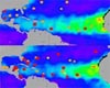
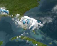
Baltimore MD (SPX) Aug 22, 2008
At 2:00 p.m. EDT, Thurs. Aug. 21, Tropical Storm Fay is finally making landfall again after meandering in the Atlantic Ocean over the last day. She was crossing Florida east coast near Flagler Beach at that time. Her center was near 28.4 degrees north latitude and 81.0 degrees west longitude.

She was trudging forward in a west-northwest direction near 2 mph. Her maximum sustained winds were still being clocked at 60 mph. Fay's minimum central pressure was near 993 millibars.

The Moderate Resolution Imaging Spectroradiometer (MODIS) on NASA's Aqua satellite took this picture of Tropical Storm Fay at 2:35 p.m. local time (18:35 UTC) on August 20, 2008.

The eye of the storm apparently hovers near the east coast of Florida, and clouds from the storm stretch hundreds of kilometers eastward over the Atlantic, and northward over Georgia and South Carolina.

Her forecast track has changed a little, based on movement of fronts and high pressure system over the next couple of days, as calculated by computer models.

She's forecast to move west across the Florida Panhandle then curve northwest into central Mississippi by Tuesday.

Community
Email This Article
Comment On This Article

Share This Article With Planet Earth
del.icio.usdel.icio.us DiggDigg RedditReddit
YahooMyWebYahooMyWeb GoogleGoogle FacebookFacebook


Related Links
Live radar from Jacksonville, Florida
Goddard Space Flight Center
Earth Observation News - Suppiliers, Technology and Application


Memory Foam Mattress Review
Newsletters :: SpaceDaily :: SpaceWar :: TerraDaily :: Energy Daily
XML Feeds :: Space News :: Earth News :: War News :: Solar Energy News


Saharan Dry, Dusty Air Lessened Intensity Of 2007 Hurricane Season
Greenbelt MD (SPX) Aug 19, 2008
A new analysis of environmental conditions over the Atlantic Ocean shows that hot, dry air associated with dust outbreaks from the Sahara desert was a likely contributor to the quieter-than-expected 2007 hurricane season.


  • Analysis: Venezuela offers oil to Paraguay
  • Consortium Formed To Expand Recycling Options For Bioplastics
  • Analysis: Cameroon controls oil peninsula
  • Nexterra Biomass Gasification Ready For Lime Kilns And Boilers

  • Iran picks firms to hunt for new nuclear plant sites
  • Spain to deal 'firmly' with nuclear plant over radioactive leak
  • Analysis: S. Korea looks to nuclear energy
  • Japan signals approval of India-US nuclear deal

  • Dutch town tests 'air-purifying' concrete
  • Scientists Search For Answers From The Carbon In The Clouds
  • Air Monitoring Helps Anticipate Possible Ecosystem Changes
  • Air Travelers And Astronomers Could Benefit From Atmospheric Turbulence Research

  • Key Georgian forests ravaged by fires: WWF
  • Forests Could Benefit When Fall Color Comes Late
  • Corruption killing Bangladesh forests: watchdog
  • Extinction Most Likely For Rare Trees In The Amazon Rainforest

  • China's top lawmakers to review food safety law: state media
  • Metropolitan Wastewater Ends Up In Urban Agriculture
  • CSIRO Enlisted To Avert Global Wheat Supply Crisis
  • PTC's Pro/Engineer Used Indian Irrigation Project

  • China sees brisk growth in auto imports, exports slow: state media
  • Energy Storage For Hybrid Vehicles
  • Towards Lower Fuel Use - Technologies For Lighter Cars
  • BMW Hydrogen 7 Hits The Road With The 2008 Hydrogen Road Tour

  • The M2-F1 - An Aircraft Without Wings
  • China's Tianjin building runway for Airbus test flights: report
  • NASA evaluates new wing sensor
  • Russia And China May Co-Design New Passenger Plane


  • The content herein, unless otherwise known to be public domain, are Copyright 1995-2007 - SpaceDaily.AFP and UPI Wire Stories are copyright Agence France-Presse and United Press International. ESA Portal Reports are copyright European Space Agency. All NASA sourced material is public domain. Additional copyrights may apply in whole or part to other bona fide parties. Advertising does not imply endorsement,agreement or approval of any opinions, statements or information provided by SpaceDaily on any Web page published or hosted by SpaceDaily. Privacy Statement