|
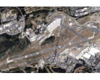
Farnborough, England (SPX) Jul 27, 2006 TopSat, the micro-satellite designed and built by a QinetiQ-led consortium of British firms, captured this image of the Farnborough International Airshow on July 18. The Farnborough International Airshow is the world's largest aerospace event. The Airbus A380 made its U.K. airshow debut at the event, and $38 billion in new business was announced during the week. TopSat is a micro-satellite system conceived to provide high resolution imaging of the Earth at low cost. A key feature of the TopSat program is the fact that the satellite was designed to return its data directly to a mobile ground station immediately after collecting an image, allowing far more timely delivery of the information it collects. TopSat is derived from Tactical Optical Satellite, emphasizing that system was specifically designed to meet operational timescales, whether for disaster relief, news-gathering, or military operations. TopSat was designed and built by a consortium of British companies led by QinetiQ, whose role included systems design and technical authority, provision of payload electronics units, operations management and the data reception element of the ground segment. Surrey Satellite Technology Ltd developed and manufactured the satellite platform and was responsible for the integration of the payload testing, arranging the launch at Cosmos, and commissioning the satellite platform in orbit through their satellite control station. Rutherford Appleton Laboratory designed and manufactured the satellite's sophisticated off-axis camera and Infoterra is marketing TopSat image products, having processed the data to recognized ortho- and geo-rectification standards. The 5-year TopSat program was jointly funded by the British National Space Center and the U.K. Ministry of Defense at a mission cost below $26 million. The satellite was successfully launched into a 700-kilometer Sun-synchronous orbit from the Plesetsk Cosmodrome in Northern Russia on Oct. 27, 2005, using a Cosmos launch vehicle. TopSat weighs just 120 kilograms (264 pounds), but carries an optical camera capable of delivering panchromatic images with a spatial resolution at nadir of 2.8 meters covering a 17-kilometer square (10.5-mile square) area, and simultaneous three-band multi-spectral images - red, green, blue - with a resolution of 5.6 meters. This is thought to represent the best resolution per mass of any satellite launched to date. This camera is integrated with an agile micro-satellite platform to permit pitch compensation maneuvers, allowing imaging of low illumination scenes. In the future, a constellation of three or four TopSat spacecraft could image almost any point on Earth at least once a day, subject to cloud conditions, further opening up the potential for quick-response imagery, which is extremely cost effective to deliver. Community Email This Article Comment On This Article Related Links QinetiQ Earth Observation News - Suppiliers, Technology and Application
 Hampton VA (SPX) Jul 25, 2006
NASA's CALIPSO spacecraft has collected its first data, considered a major milestone for one of the agency's newest satellite missions. |
|
| The content herein, unless otherwise known to be public domain, are Copyright 1995-2006 - SpaceDaily.AFP and UPI Wire Stories are copyright Agence France-Presse and United Press International. ESA PortalReports are copyright European Space Agency. All NASA sourced material is public domain. Additionalcopyrights may apply in whole or part to other bona fide parties. Advertising does not imply endorsement,agreement or approval of any opinions, statements or information provided by SpaceDaily on any Web page published or hosted by SpaceDaily. Privacy Statement |