|
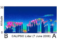
Hampton VA (SPX) Jul 25, 2006 NASA's CALIPSO spacecraft has collected its first data, considered a major milestone for one of the agency's newest satellite missions. CALIPSO, or Cloud-Aerosol Lidar and Infrared Pathfinder Satellite Observations, seeks to reveal the secrets of clouds and aerosols, tiny particles suspended in the air, enabling scientists to study how they form, evolve and interact and how they affect our air quality, weather and climate. Shown above is one of the satellite's first lidar images - a unique vertical view of the atmosphere. CALIPSO's innovative lidar system is an active remote sensing technique, similar to radar in operation. Lidar emits short pulses of green and infrared light - rather than the microwaves used by radar - which are reflected from cloud and aerosol particles in the atmosphere. Each lidar sample produces a 300-feet wide snapshot or profile of the atmosphere. Profiles collected along an orbit are streamed together to paint a picture of what a vertical slice of our atmosphere looks like. On June 7, during its first day of lidar operations, CALIPSO observed the layers of clouds and aerosols shown here in an orbit over eastern Asia, Indonesia and Australia. In the lower right hand portion of the image is the trace of the changing surface elevation of the Australian continent, a low horizontal line. Just above the surface, in a layer several kilometers deep, a layer of aerosol particles is shown in shades of orange and red. The greenish-yellow and blue colors indicate the lidar signal reflected from air molecules. Clouds are especially easy to detect and are displayed by the brighter colors of pink and white. We can see that some of these clouds are quite dense because the region below them is shown as nearly black - the light from the lidar cannot penetrate the thick clouds. Also visible are thin tropical cirrus clouds shown in greenish-blue, at a height of 12 to 15 kilometers (about 7 to 9 miles). There was a range bias at the time this data was acquired, so the ocean surface appears to be at an altitude of -500 meters (-1650 feet). This image also illustrates an exciting feature of the CALIPSO satellite, the ability to detect and track volcanic plumes. On May 20, a major lava dome collapse took place at the Soufriere Hills Volcano on the island of Montserrat in the Caribbean Sea. The dome collapse involved an explosion that sent ash clouds to 17 kilometers (about 10.5 miles) high, probably entering the lower stratosphere. The sulfur dioxide column from this volcanic activity has been tracked by the Ozone Monitoring Instrument on NASA's Aura spacecraft for several weeks. On June 6 and 8, OMI observed the sulfur dioxide plume over Indonesia, and in the lidar curtain profile above you can see a thin scattering layer at an altitude of about 20 kilometers (about 12 miles). Because of the altitude and the correlation with the location of the plume, the very thin layer of clouds appears to be the aerosol component of the plume from Soufriere. The layer appears to be non-depolarizing, so it may be primarily composed of sulfuric acid droplets, rather than ash particles. Volcanic plumes such as this can be hazardous to air traffic if they cross air traffic lanes at the altitude where commercial aircraft fly. The ability of CALIPSO to observe the location, altitude, optical properties and movement of aerosols around the globe improves our ability to assess and forecast episodes of poor air quality. Community Email This Article Comment On This Article Related Links Calipso Earth Observation News - Suppiliers, Technology and Application
 Paris, (ESA) Jul 16, 2006
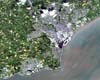
Cardiff, the capital city of Wales, is featured in this image taken by Japan's Advanced Land Observation Satellite. Recognised as the capital in 1955, Cardiff is Europe's youngest capital city. |
|
| The content herein, unless otherwise known to be public domain, are Copyright 1995-2006 - SpaceDaily.AFP and UPI Wire Stories are copyright Agence France-Presse and United Press International. ESA PortalReports are copyright European Space Agency. All NASA sourced material is public domain. Additionalcopyrights may apply in whole or part to other bona fide parties. Advertising does not imply endorsement,agreement or approval of any opinions, statements or information provided by SpaceDaily on any Web page published or hosted by SpaceDaily. Privacy Statement |