|
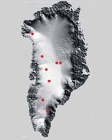
Columbus OH (SPX) Dec 18, 2006 In the first test of a new radar instrument, scientists have seen through more than a mile of Greenland ice to reveal an image of land that has been hidden for millions of years. Ohio State University scientists and their colleagues will use what they learn from the instrument, dubbed GISMO (for Global Ice Sheet Mapping Orbiter), to determine how global climate change will affect the ice. "One of the key things we need to know to predict how the ice sheet is going to change in the future is the distribution -- and the change in distribution -- of sub-glacial water," said Ken Jezek, professor of earth sciences at Ohio State. "So our dream is to create this new image of what Greenland would look like, were the ice sheets stripped away." Jezek said that beneath the ice, Greenland topography matches that of Canada and the northern United States, with much of the land scoured flat by flowing ice. There are also mountains and valleys, and perhaps rivers and lakes. In the past, scientists who wanted to study Greenland's ground profile from an aircraft could only acquire data from directly beneath the aircraft. Those radar profiles were effectively two dimensional -- they gave the height of a particular spot of land directly along the thin line of the flight path. Jezek and the GISMO team acquired the first effectively three-dimensional image of the ground -- in a strip about a mile wide, 1.2 miles beneath the ice. They were able to do so because GISMO features multiple, electronically steerable antennas which operate while the airplane is flying, coupled with special processing algorithms. The mile-wide strip is narrow by Jezek's standards; he plans to take data from wider swaths of land in the future. The challenge is to find a way to process the data from the sides of the strip, which is much more complicated than processing data from directly below the aircraft. In fact, the GISMO team is still processing the data from that first test run, in May 2006. But even the early unfinished image offers the suggestion of a rise and fall in the topography -- perhaps gently rolling plains. Ohio State graduate student Noppasin Niamsuwan unveiled the radar image in a presentation Tuesday, December 12, 2006 at the American Geophysical Union annual meeting in San Francisco. Joel Johnson, professor of electrical engineering and Niamsuwan's advisor, is helping to develop techniques to process the GISMO signals, and reveal as much about the sub-ice topography as possible. Since nobody's seen beneath the ice in this way before, there's no standard strategy to use. Still, Johnson's own satellite studies of ocean waves could pay off as they try to decipher the signals from water flowing beneath the ice. "What's the radar signature for water at the base of the ice sheet?" Jezek asked. "That's what we want to know, and that's where Noppasin comes in." At the American Geophysical Union meeting, Niamsuwan described his tests of various computer models that will help answer the question. As scientists try to gauge the effects of global climate change, they are beginning to look very closely at conditions beneath Earth's ice sheets, which cover roughly 15 percent of the planet. Earth's poles have been covered in ice for 2.7 million years. Scientists suspect that, just as the ice surface has changed over that time, a different world has evolved underneath. Scientists know that rising global temperatures have caused surface ice to melt; the meltwater percolates down through cracks in the ice. But what happens in the invisible region underneath -- where ice meets rock, soil, and water -- is largely unknown. Sub-glacial lakes and rivers could lubricate the ice against the rock, and speed the iceflow above. So this hidden water could have a great deal of influence on how much of the ice may melt because of rising temperatures, and how much global sea level may rise as a result. Confirming that hypothesis is difficult. Surface crevasses often obscure the view for traditional radar systems. GISMO gets around the problem by combining radar signals reflected from the surface of the ice with signals from the base of the ice. The two signals combine to produce an interference pattern, just like light waves interfere with each other to produce a rainbow effect on a puddle of oily water. In that case, a thin layer of oil floats on the water, and light reflecting off the surface of the oil clashes with light reflecting off the surface of the water below. Jezek's team is developing techniques that use the interference pattern to cancel out the effects of surface ice and reveal the base of the ice sheet. Applying the technique to the data collected in May 2006 creates an image that resembles the rainbow on an oily puddle. The results from Ohio State's computer simulations will help them interpret GISMO's first image, and the new images they'll take in Greenland in April 2007. Jezek plans to ride on the plane as the GISMO data streams into a laptop computer. The team will fly above the rough ice along the coast, and then head inland over smoother terrain. GISMO's design is similar to a radar system previously developed by the University of Kansas in partnership with Ohio State. While that early radar system slid along the surface of the ice, and GISMO works from an airplane, Jezek envisions a GISMO-like instrument could one day operate from a satellite. Then scientists could use it to study ice sheets all over the world -- or on other planets. Other possible research targets in the solar system include the Martian ice caps or the frozen Jovian moon Europa. NASA's Earth Science Technology Office sponsored this work, and partners on the project include the University of Kansas, and NASA's Jet Propulsion Laboratory and Wallops Flight Facility. Commercial partners are Vexcel Corp. of Boulder, CO, and EG&G Corp. of Wallops Island, VA. Community Email This Article Comment On This Article Related Links Ohio State University Beyond the Ice Age
 Huntsville AL (SPX) Dec 15, 2006
Readers of Science@NASA may remember six fun months in 2002-03 when astronaut Don Pettit circled Earth onboard the International Space Station (ISS). Don was the expedition's science officer--and more than that, he was infected with a mischievous sense of experimentation. |
|
| The content herein, unless otherwise known to be public domain, are Copyright 1995-2006 - SpaceDaily.AFP and UPI Wire Stories are copyright Agence France-Presse and United Press International. ESA PortalReports are copyright European Space Agency. All NASA sourced material is public domain. Additionalcopyrights may apply in whole or part to other bona fide parties. Advertising does not imply endorsement,agreement or approval of any opinions, statements or information provided by SpaceDaily on any Web page published or hosted by SpaceDaily. Privacy Statement |