|
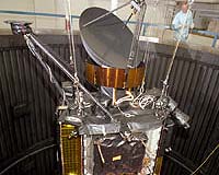
Boulder CO (SPX) Jun 20, 2007 The Quick Scatterometer (QuikSCAT) satellite built by Ball Aerospace and Technologies Corp. completed eight years of outstanding on-orbit operations today, performing six years beyond its minimum two-year mission requirement. QuikSCAT continues to return critical wind data to forecast hurricanes and El Nino effects and pinpoint typhoons and other marine storms, as well as help scientists measure the mass of the Antarctic and Greenland ice sheets. QuikSCAT data has improved the warning time for tropical cyclone development in the Atlantic and Eastern Pacific hurricane basins. Using wind field data from QuikSCAT, researchers are able to detect potential cyclones in these regions earlier than traditional capabilities allowed. This early detection of storms could allow residents more time to prepare for adverse weather conditions. "QuikSCAT has clearly demonstrated its reliability to both government and commercial customers, providing quality forecasting data to scientists and meteorologists -- the type of data that could easily be extended with a new scatterometer mission," said David L. Taylor, president and CEO of Ball Aerospace. QuikSCAT is a polar orbiting satellite with an 1800 km wide measurement swath on the earth's surface, circling the earth from a distance of 800 km (500 miles). Generally, this results in 400,000 measurements daily over a given geographic region. The onboard SeaWinds scatterometer has enhanced global climate research by recording sea-surface winds over the oceans on a 25km x 25km spatial scale. NASA awarded its first Rapid Spacecraft Acquisition fixed-price contract to Ball Aerospace for the QuikSCAT, which was completed in 11 months -- an industry record for a spacecraft of its size. The QuikSCAT Ball Commercial Platform (BCP 2000) architecture has since been used for the Ball Aerospace-built QuickBird I and II satellites, the ICESat and CloudSat satellites, and the National Polar-Orbiting Operational Environmental Satellite System Preparatory Project. Designed to measure ocean winds, SeaWinds has proven useful in many other applications. Earlier this year, it detected the most widespread Antarctic melting ever observed using satellites during the past three decades. In 1999, it detected a mammoth, previously lost iceberg called B10A in the Drake Passage shipping lane. The iceberg is now tracked for the National Ice Center to route supply ships into and out of Antarctica's McMurdo station. Email This Article
Related Links
 Kiev, Ukraine (RIA Novosti) Jun 19, 2007
Ukraine is planning to launch a Sich-2 Earth remote sensing satellite into orbit in 2008, the National Space Agency said on its web site. The former Soviet republic has been conducting space activities since 1993 "for the benefit of the national economy and state security as well as to be able to break into the international space services market." |
|
| The content herein, unless otherwise known to be public domain, are Copyright 1995-2006 - SpaceDaily.AFP and UPI Wire Stories are copyright Agence France-Presse and United Press International. ESA PortalReports are copyright European Space Agency. All NASA sourced material is public domain. Additionalcopyrights may apply in whole or part to other bona fide parties. Advertising does not imply endorsement,agreement or approval of any opinions, statements or information provided by SpaceDaily on any Web page published or hosted by SpaceDaily. Privacy Statement |