|
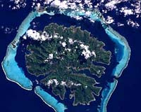
Houston TX (SPX) Nov 05, 2004 A collection of 1,490 coral reef images has become the basis for a new Internet- based library for the Millennium Coral Reef Project. It was created in a partnership with NASA, international agencies, universities and other organizations to provide natural resource managers a comprehensive world data resource on coral reefs and adjacent land areas. The integrated Remote Sensing of Coral Reefs and Millennium Coral Reef Mapping projects have many partners including NASA, the National Oceanic and Atmospheric Administration, and the University of South Florida (USF), which are providing funding, data or manpower. The current knowledge about the total area and locations of coral reefs worldwide is not adequate to see changes that occur in them. "Remote sensing of coral reefs has been a rapidly developing research area," said Julie A. Robinson, the scientist who managed the project for the Earth Observations Laboratory at the NASA Johnson Space Center (JSC), Houston, Texas. NASA has contributed funding and satellite data to the project, whose purpose is to develop global reef maps as a base for future research. The project will also serve as a library for the coral reef remote sensing data. From 1999 to 2003, the Landsat 7 satellite took the 1,490 images of coral reefs to complete the required global coverage. Landsat is managed by the U.S. Geological Survey (USGS). The images and data were assembled by the Institute for Marine Remote Sensing (IMaRS) at USF, St. Petersburg, Fla. "There has been amazing cooperation at all levels to assemble this data together," said Frank Muller-Karger, of USF. The Landsat 7 Science Team specifically scheduled observations of many reef areas for the first time. The final map products are due for release in early 2005. Currently, the raw archive is available on the Internet at http://seawifs.gsfc.nasa.gov/cgi/landsat.pl. The archive and online data interface were developed by the SeaWiFS Project at NASA's Goddard Space Flight Center (NASA/GSFC) in Greenbelt, Md. "The archive is our first completed product and will immediately provide data to improve local assessments of reef resources around the world," Robinson said. "This data archive provides access to a reliable global satellite dataset for mapping coral reefs. It will serve as a source of data for projects around the world," said Serge Andr�fou�t, who led data collection and mapping at USF and is now with the French Institut de Recherche pour le D�veloppement (IRD) in New Caledonia. USF in collaboration with JSC is characterizing, mapping and estimating extent of shallow coral reef ecosystems in the Caribbean-Atlantic, Pacific, Indo-Pacific and Red Sea using the Landsat images. The archive highlights similarities and differences between reef structures at a scale never before considered by traditional field studies. Other partners include the United Nations Environment Programme's World Conservation Monitoring Centre (UNEP-WCMC), and the World Fish Center's ReefBase Project. "Current estimates of the extent, health and even the location of the world's coral reefs are completely inadequate to answer the key question about the how reefs and the fragile ecosystems that they support are adapting to a changing environment. This newly released data set will help provide the baseline against which future observations can be compared," said Gene Carl Feldman, SeaWiFS Project manager, NASA/GSFC. Community Email This Article Comment On This Article Related Links Remote Sensing of Coral reefs Millennium Coral Reefs Landsat archive SeaWiFS Project at GSFC Institute for Marine Remote Sensing SpaceDaily Search SpaceDaily Subscribe To SpaceDaily Express Dirt, rocks and all the stuff we stand on firmly
 Paris (ESA) Jan 12, 2006
Using the ESA Cluster spacecraft and the NASA Wind and ACE satellites, a team of American and European scientists have discovered the largest jets of particles created between the Earth and the Sun by magnetic reconnection. This result makes the cover of this week's issue of Nature. |
|
| The content herein, unless otherwise known to be public domain, are Copyright 1995-2006 - SpaceDaily.AFP and UPI Wire Stories are copyright Agence France-Presse and United Press International. ESA PortalReports are copyright European Space Agency. All NASA sourced material is public domain. Additionalcopyrights may apply in whole or part to other bona fide parties. Advertising does not imply endorsement,agreement or approval of any opinions, statements or information provided by SpaceDaily on any Web page published or hosted by SpaceDaily. Privacy Statement |