|
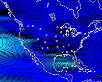
Washington DC (SPX) Nov 08, 2004 NOAA's Space Environment Center and National Geodetic Survey recently released (November 1) new experimental ionosphere products to help emergency managers and other users quickly assess the effects of solar storm on Global Positioning System applications. NOAA, the National Oceanic and Atmospheric Administration, is an agency of the U.S. Department of Commerce. The SEC has created a near real-time ionospheric specification map of total electron content over the continental United States that updates every 15 minutes. The USTEC map, available online at http://www.sec.noaa.gov/ustec , will aid users affected by ionospheric conditions - GPS applications, surveyors, emergency managers, and others - to quickly assess the current situation that may impact their systems. The ionosphere is the area of the Earth's atmosphere beginning at an altitude of about 30 miles and extending upwards to 10,000 miles. Free electrons slow and disrupt the GPS signal as it passes through the ionosphere. "This map is the initial offering in an ongoing effort to provide improved products and services to a significant part of the SEC users community," said Ernest Hildner, director of NOAA's Space Environment Center in Boulder, Colo. Past maps and related source data will be available from the National Geophysical Data Center Web site This product results from contributions of the National Geodetic Survey, National Geophysical Data Center, Forecast Systems Lab, and the Cooperative Institute for Research in the Environmental Sciences at the University of Colorado. The NGS also announce two new ionosphere models over the continental United States. These two highly accurate models (MAGIC and ICON-1) use the full set of Continuously Operating Reference Stations and provide ionospheric information between CORS stations and GPS satellites with a three-day delay. Thanks to these models, users will be able to more precisely compute positions from GPS. Both MAGIC and ICON-1 are prototype models, part of ongoing research projects, but are being made available free to the general public for testing and evaluation purposes. They may be found at http://www.ngs.noaa.gov/Ionosphere. Community Email This Article Comment On This Article Related Links NOAA SpaceDaily Search SpaceDaily Subscribe To SpaceDaily Express GPS Applications, Technology and Suppliers
 Cheltenham, England (SPX) Jan 09, 2006
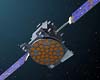
Marotta UK is pleased to announce that it designed, developed and qualified equipment for the cold gas propulsion systems on board the Galileo GIOVE-A, part of Europe's Galileo navigation program, successfully launched by Surrey Satellite Technology (SSTL). |
|
| The content herein, unless otherwise known to be public domain, are Copyright 1995-2006 - SpaceDaily.AFP and UPI Wire Stories are copyright Agence France-Presse and United Press International. ESA PortalReports are copyright European Space Agency. All NASA sourced material is public domain. Additionalcopyrights may apply in whole or part to other bona fide parties. Advertising does not imply endorsement,agreement or approval of any opinions, statements or information provided by SpaceDaily on any Web page published or hosted by SpaceDaily. Privacy Statement |