|
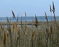
Woods Hole MA (SPX) Apr 28, 2008 From the distant reaches of the universe, to black holes and Saturn's rings, NASA explores some of the most far-out parts of space. But NASA also does research much closer to home. In fact, NASA Earth Science satellites are taking part in the management and recovery of an ecosystem right in our own backyard, the Chesapeake Bay. By studying the landscape around the Chesapeake, NASA spacecraft such as Landsat, Terra and Aqua are helping land managers figure out how to battle the harmful pollutants that have added to the destruction of the bay's once legendary productivity. While still a commercially important ecosystem -- home to some 3,600 species -- four centuries of local population growth have crippled the bay's health, earning it a place on the U.S. Environmental Protection Agency's "dirty waters" list and a 2007 overall grade of C-minus by the University of Maryland Center for Environmental Science. Many of these harmful pollutants come from the Chesapeake Bay's watershed, an area of about 64,000 square miles that covers parts of six states. Water from this massive region constantly drains into the bay, carrying with it sediments from erosion, excessive nutrients and other contaminants that hurt the bay's water quality. This runoff also feeds large algae blooms that consume oxygen in the water; oxygen that crabs, fish and other bay species rely on. Runoff carries more pollutants when it travels over paved surfaces and cropland, versus marshland or forest. Land cover information from satellite imagers like Landsat and the Moderate Resolution Imaging Spectroradiometer (MODIS) help Bay managers identify the best places to curb non-point source pollution. "The impervious, tree cover and land cover type map products derived from Landsat data are used on a daily basis by the Chesapeake Bay Program," says Scott Goetz, a NASA-funded scientist at Woods Hole Research Center, whose team used Landsat data to create a series of Chesapeake watershed maps. The Chesapeake Bay Program is a unique regional partnership that leads and directs the restoration of the bay. They often use Landsat data to help build models that predict the location of nutrient loads and identify areas where managers should take action towards conservation, restoration and growth. In addition, NASA sensors SeaWiFS and MODIS detect water color, and are used to calculate sediment and chlorophyll concentrations. The National Oceanic and Atmospheric Administration's CoastWatch program provides this type of oceanographic data in near real-time to federal, state and local marine scientists, coastal resource managers and the general public. Other organizations, such as the Virginia Department of Conservation and Recreation and the Maryland Department of Natural Resources, also use NASA-derived information to prioritize land conservation efforts. The states have now set nutrient and sediment reduction targets for each of the Chesapeake watershed sub-regions thanks to a Landsat-enabled assessment of relative pollution contributions. In all these ways, NASA satellites are helping Chesapeake Bay managers reduce harmful pollutants. If the bay is ever to recover enough to be taken off of the "dirty waters" list, NASA data will be essential for deciding how to best care for our troubled neighbor. Community Email This Article Comment On This Article Related Links Take an interactive Chesapeake tour Earth Observation News - Suppiliers, Technology and Application
 Bangalore, India (AFP) April 24, 2008
An Indian rocket will next week launch an advanced remote-sensing satellite that will help plan and implement urban and rural development projects, the space agency said Thursday. |
|
| The content herein, unless otherwise known to be public domain, are Copyright 1995-2007 - SpaceDaily.AFP and UPI Wire Stories are copyright Agence France-Presse and United Press International. ESA Portal Reports are copyright European Space Agency. All NASA sourced material is public domain. Additional copyrights may apply in whole or part to other bona fide parties. Advertising does not imply endorsement,agreement or approval of any opinions, statements or information provided by SpaceDaily on any Web page published or hosted by SpaceDaily. Privacy Statement |