|
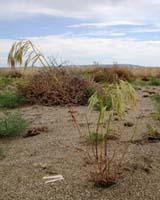
Richland WA (SPX) Jun 19, 2006 Cheatgrass, a fast-growing, fire-fueling weed, has met its match. The Idaho Bureau of Land Management and several weed control groups are fighting back with new software that uses NASA satellite imagery and complex computer programs to show the location and growth of this noxious plant that has invaded the arid West from desert lowlands to high mountains. The technology is available to local and state agencies through the Pacific Northwest Regional Collaboratory, the partnership of scientists and engineers from area universities and Department of Energy national laboratories that developed the software. Cheatgrass has little forage value, increases the frequency of wildfires and elbows out native species, promoting soil erosion and reducing the value of pasture lands. Invasive plants such as cheatgrass cost land managers billions of dollars each year and have encroached upon more than 100 million acres in the United States. Known by several names, including downy brome and June grass, cheatgrass is bright green in the late fall and early spring. It turns a rusty red to purple at maturity, making it easy to spot in the late spring when other plants are green. Its spiky seed heads are infamous for attaching themselves to socks, fur and animals' ears. "The best way to get a handle on the extent of cheatgrass and target large areas for treatment is to look at the big picture," said project ecologist Janelle Downs, a senior research scientist at Pacific Northwest National Laboratory. "NASA satellite imagery provides that big landscape picture and lets land managers be smarter in using their treatment dollars," Downs said. PNNL's Roger Anderson, collaboratory manager, explained that, although satellites of NASA's Earth Observing System measure the energy bounced back by the earth's surface and send terabytes of data every day to NASA stations on earth, the data have not been accessible to many resource managers because of the cost, time and training required for data acquisition and processing. The collaboratory developed software that analyzes data across thousands of square miles of potentially affected landscape. Resource mangers can zero in on their area of interest and display details of cheatgrass and shrub cover in different colors. "This new software is a significant improvement over the previous method," said Jeffrey Pettingill, superintendent of the Bonneville County (Idaho) Weed Department. "We used to just get in the pickup truck, get up to about 60 miles per hour and look out the window." For information regarding access to the cheatgrass data, contact Steve Gajewski at 509/372-4389. The mission of the collaboratory is to turn data from satellites and other sources into information land managers can use to protect Northwest streams, forests, farmland and urban areas. Members are the Idaho National Laboratory, Idaho State University, Oregon State University, PNNL, the University of Idaho and the University of Washington. Community Email This Article Comment On This Article Related Links The Idaho Bureau of Land Management Pacific Northwest Regional Collaboratory Earth Observation News - Suppiliers, Technology and Application
 Longmont CO (SPX) Jun 19, 2006
Healing Hands International (HHI), a non-profit humanitarian organization, is working with the Native Communities Development Corporation (NCDC), a DigitalGlobe business partner, to obtain satellite imagery from DigitalGlobe for use in planning and visualization efforts surrounding agricultural development and disaster relief missions in Africa and Central America. |
|
| The content herein, unless otherwise known to be public domain, are Copyright 1995-2006 - SpaceDaily.AFP and UPI Wire Stories are copyright Agence France-Presse and United Press International. ESA PortalReports are copyright European Space Agency. All NASA sourced material is public domain. Additionalcopyrights may apply in whole or part to other bona fide parties. Advertising does not imply endorsement,agreement or approval of any opinions, statements or information provided by SpaceDaily on any Web page published or hosted by SpaceDaily. Privacy Statement |