|
Longmont CO (SPX) Jun 19, 2006 Healing Hands International (HHI), a non-profit humanitarian organization, is working with the Native Communities Development Corporation (NCDC), a DigitalGlobe business partner, to obtain satellite imagery from DigitalGlobe for use in planning and visualization efforts surrounding agricultural development and disaster relief missions in Africa and Central America. HHI provides sustainability education and training to third-world countries. Its mission is to implement efficient and lasting sustainable technologies, paving the way for agricultural economies in rural areas of developing countries to feed starving communities. DigitalGlobe's satellite imagery of Honduras, Nigeria and Senegal have been instrumental in allowing HHI to assess agriculture potential and conduct pre-planning before visiting the location to implement agricultural programs like drip irrigation systems and training. HHI provides relief assistance to developing countries devastated by natural disasters. Before and after imagery of Madras, India - an area still suffering the effects of the December 2004 Indian Ocean tsunami - is helping HHI to assess the extent of damage and plan for reconstruction and development initiatives. The imagery allows HHI to prioritize its efforts and develop detailed rebuilding plans to ensure that, once on the ground, precious time and resources are leveraged. The imagery is also helpful for planning access to devastated rural areas. NCDC's Satellite and Imaging Division is also supplying training courses to HHI. The courses emphasize the use of ESRI's ArcGIS software package for analyzing and viewing the satellite imagery in a geographic information systems environment. "NCDC maintains a strong commitment to community development efforts, and we are passionate about supporting humanitarian initiatives that work toward improving the lives of our fellow global community members," said Jason San Souci, COO of NCDC. "I have been a long-time believer in the use of aerial and satellite imagery for agriculture planning and mapping," said Dave Goolsby, director of International Agricultural Development & Relief, HHI. "In the future, I want to expand our use of imagery to assess the progress of our important rebuilding and agricultural program implementations." Community Email This Article Comment On This Article Related Links DigitalGlobe Earth Observation News - Suppiliers, Technology and Application
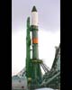 Moscow, Russia (AFP) Jun 16, 2006
Russia on Thursday launched a new remote-sensing satellite which is due to take high-resolution photographs of Earth, Russian mission control said. The Resource DK1 satellite was launched from the Baikonur cosmodrome in Kazakhstan by the Soyuz-U launch vehicle at midday (0800 GMT) and went into orbit almost nine minutes later, mission control spokesman Valery Lydnin said. |
|
| The content herein, unless otherwise known to be public domain, are Copyright 1995-2006 - SpaceDaily.AFP and UPI Wire Stories are copyright Agence France-Presse and United Press International. ESA PortalReports are copyright European Space Agency. All NASA sourced material is public domain. Additionalcopyrights may apply in whole or part to other bona fide parties. Advertising does not imply endorsement,agreement or approval of any opinions, statements or information provided by SpaceDaily on any Web page published or hosted by SpaceDaily. Privacy Statement |