|
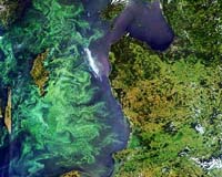
Vancouver BC (SPX) Jun 14, 2006 A team led by Canadian firm Hatfield Consultants, under the ESA-funded Chilean Aquaculture Project, is using ESA's Envisat spacecraft to detect potential harmful algal blooms that could endanger Chile's aquaculture projects. Chile currently is the world's largest producer of farmed salmon and has a burgeoning mussel culture industry that is supplying a growing world market. The country's marine aquaculture sector, however, is vulnerable to harmful algal blooms, which occur when some algae species producing poisons bloom rapidly in water, causing physical or biochemical damage to fish and shellfish. Early detection of HABs allows fish farmers to make timely key decisions in order to minimize the damage to aquaculture. HABs are a natural phenomenon that have increased in frequency over the last 30 years, causing millions of Euros worth of annual losses to the 360 fish farms found in the southern region of Chile. They deplete the concentration of oxygen in sea water, potentially killing larger caged fish such as salmon that cannot flee the affected area. In the case of shellfish, such as mussels, toxins from the blooms accumulate in their body tissues and pose serious health risks for humans when consumed. For instance, in 2002 an HAB outbreak in Chile was responsible for 73 paralytic poisonings and two deaths. In 2004, more than 1,500 cases of poisonings occurred resulting in an estimated 30 million Euro yearly loss. And in 2005, more than 10,000 cases were document, including one death. Just like plants on land, algae employ green-pigmented chlorophyll for photosynthesis - the process of turning sunlight into chemical energy. The chlorophyll collectively tints the color of the surrounding water, providing a means of detecting these tiny organisms from space with dedicated ocean color sensors onboard satellites. The CAP project utilizes a combination of near real-time EO data, such as chlorophyll - a pigment concentration, secchi transparency, suspended matter and sea-surface temperature derived from the MERIS instrument onboard ESA's Envisat satellite and the MODIS instrument onboard NASA's Aqua satellite and in situ water monitoring to monitor the Southern Ocean off the coast of Chile. A hydrodynamic model, established and validated through the project, is also used to characterize the water circulation patterns in the major aquaculture area in southern Chile. Aquaculture has become a capital-intensive industry in Chile, worth nearly 1 billion Euros a year with direct and indirect benefits for employment and other industries. The aquaculture industry in Chile and internationally has expressed great interest in the products and services developed under the CAP project. In particular, the HAB early warning service has been tested by Mainstream Chile, part of the Norwegian holding company CERMAQ, a world leader in salmon production. "The benefits of the CAP project are directly related to the operation of our company," said Francisco Puga, Mainstream Group's development manager. Environmental monitoring and HAB detection is part of the company's daily operation procedures, he added, and historical environmental information supports strategic decisions for farm site location. "To obtain the amount of information covered with the EO data, alternative methods will be of considerable higher cost," Puga said. "With in situ measurements you cannot produce a gradient map as obtained with EO images. The value of this information is the area and resolution obtained in a single didactic image." Last month, the CAP project was presented at the AQUA2006 event organized by the World Aquaculture Society in Florence, Italy, triggering a lot of interest for EO-based information service in the aquaculture industry. The CAP team, including Canada's Hatfield, France's ACRI, Chile's Mainstream Chile and Italy's AVS, has been supported within the framework of ESA's Earth Observation Market Development program. Community Email This Article Comment On This Article Related Links Hatfield Consultants Earth Observation Market Development Earth Observation News - Suppiliers, Technology and Application
 Mountain View CA (SPX) Jun 14, 2006
Google has announced a series of updates to the company's mapping product suite, further illustrating Google's commitment to creating powerful tools for sharing geographic information. Announced live at Google's first Geo Developer Day, these innovations both connect users to information about the world around them, as well as address the growing needs of the developer community. |
|
| The content herein, unless otherwise known to be public domain, are Copyright 1995-2006 - SpaceDaily.AFP and UPI Wire Stories are copyright Agence France-Presse and United Press International. ESA PortalReports are copyright European Space Agency. All NASA sourced material is public domain. Additionalcopyrights may apply in whole or part to other bona fide parties. Advertising does not imply endorsement,agreement or approval of any opinions, statements or information provided by SpaceDaily on any Web page published or hosted by SpaceDaily. Privacy Statement |