|
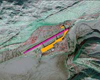
Dulles VA (SPX) Jun 21, 2006 GeoEye announced Wednesday the National Geospatial-Intelligence Agency Stereo Airfield Collection program has awarded the company $3.7 million to image 365 airfields and produce Airport Mapping Databases over a 12-month period. GeoEye will deliver IKONOS stereo imagery and perform three-dimensional airport feature extraction services in accordance with NGA specifications. This is the NGA's third and largest Airport Mapping Database award to GeoEye, following two prior awards for three airfields in 2004 and 15 airfields in 2005. The new award takes effect immediately. GeoEye is now the world's largest developer of airport geospatial information support, terrain and obstacle databases with several hundred airfields mapped to date. "We are a leader in providing airport geospatial solutions to key customers like the NGA and the USAF at the best price and with the best performance in the industry," said Matt O'Connell, GeoEye's president and chief executive officer. An Airport Mapping Database contains significant features of an airport such as runways, taxiways, buildings, obstacles and terrain surrounding an airfield. This information supports the safe movement of aircraft and helicopters on runways and taxiways. Such products also can be used to support training, mission or contingency planning and visual simulations for ordinary operations or crisis situations. GeoEye is uniquely positioned to fulfill this contract for North American and international airfields by virtue of its IKONOS satellite's ability to generate a three-dimensional image from stereo data collected during a single orbital pass. The result is a three-dimensional map-accurate image of an airport that can be quickly and cost effectively acquired. "We are also completing a project for 13 commercial airports in South America for the Latin American Civil Aviation Commission," said Dejan Damjanovic, GeoEye's program manager for airfield and harbor mapping. As GeoEye's single biggest customer, the NGA has awarded the company more than $50 million in 2006 for imagery and services. GeoEye is currently building its next-generation commercial satellite imaging system, GeoEye-1, which will provide a ground resolution of 0.41-meter panchromatic and 1.65-meter multispectral or color imagery. The launch of GeoEye-1 is slated for early 2007 from the Vandenberg Air Force Base in California. Community Email This Article Comment On This Article Related Links GeoEye Earth Observation News - Suppiliers, Technology and Application
 Richland WA (SPX) Jun 19, 2006
Cheatgrass, a fast-growing, fire-fueling weed, has met its match. The Idaho Bureau of Land Management and several weed control groups are fighting back with new software that uses NASA satellite imagery and complex computer programs to show the location and growth of this noxious plant that has invaded the arid West from desert lowlands to high mountains. |
|
| The content herein, unless otherwise known to be public domain, are Copyright 1995-2006 - SpaceDaily.AFP and UPI Wire Stories are copyright Agence France-Presse and United Press International. ESA PortalReports are copyright European Space Agency. All NASA sourced material is public domain. Additionalcopyrights may apply in whole or part to other bona fide parties. Advertising does not imply endorsement,agreement or approval of any opinions, statements or information provided by SpaceDaily on any Web page published or hosted by SpaceDaily. Privacy Statement |