|
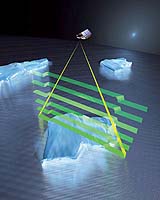
Paris, France (ESA) Mar 13, 2007 Building a satellite in just three years is without doubt an ambitious undertaking. Nevertheless, the decision to rebuild CryoSat and recover the mission includes just that goal. A year on and the mission is now well on the way to recovery, with a design that incorporates no less than 85 separate improvements. The CryoSat-2 satellite replaces CryoSat, which was lost as a result of launch failure in October 2005. With the threat of receding ice cover in the polar regions, thought to be due to climate change, the need to understand the extent to which this may be happening is even more relevant today than it was when the first CryoSat was selected for development in 1999. The International Polar Year 2007-2008 (IPY) will focus resources on making measurements of our polar environments. The loss of the original CryoSat prevented it contributing to this effort but the exploitation of CryoSat-2 will benefit from the IPY. Although the impact of climate change is expected to be amplified at the poles, it is extremely difficult to determine what effect this is having on the polar ice cover. Recent reports of receding sea ice in the Arctic and the break-up of the edges of the massive Antarctic ice sheet are much in the public eye. On the other hand, there have also been reports of the ice at the North Pole being thicker than usual. Scheduled for launch in 2009, CryoSat-2 will measure fluctuations in the thickness of ice on both land and sea to provide conclusive evidence as to whether there is indeed a trend towards diminishing ice cover. Moreover, since ice plays such an important role in the Earth system, predicting future climate and sea level depends on the data that CryoSat-2 will realise. In the year since the go-ahead to build CryoSat-2, much has been achieved and the project has just passed an important milestone, that being the Critical Design Review during which all the changes to the design were scrutinised. Notable among the changes, is the decision to have the satellite carry a back-up for the main payload, the SAR/Interferometric Radar Altimeter (SIRAL). This means fitting in a complete second set of electronics. Radar altimeters have been flown in space before, but the SIRAL is a radar with a difference. Its sophisticated design encompasses enhanced resolution and observing capabilities to meet the challenges of acquiring accurate measurements of the thickness of floating sea ice, whilst also being able to survey the surface of vast ice sheets accurately enough to detect small changes. As a result of the dual SIRAL payload and associated interfaces, and other improvements to reliability, there has been a knock-on effect to the design of the satellite. For example, the back-up SIRAL has to be kept warm while it is switched off - the additional heater power is provided by increasing the size of the satellite's battery. Some minor shortcomings found in the original design have been fixed and other changes were needed to replace obsolete equipment and parts. Overall 85 separate improvements were specified of which 30-40% have been small software changes that make the satellite much easier to operate. Richard Francis, ESA CryoSat-2 Project Manager said, "We hit the ground running with CryoSat-2. After the launch failure we managed to get ourselves organised pretty quickly so that when we got the go-ahead for CryoSat-2 we knew exactly what to do. Our industrial team has made astonishing progress in the last year with some flight hardware already delivered. "So far everything's on track and we expect that to continue, so that by the end of 2007 our beloved CryoSat will be almost completely reassembled." In addition to building the new satellite, a number of field experiments to support the mission are getting underway in the Arctic. First is the Arctic Arc Expedition, part of the International Polar Year. The expedition's two Belgian explorers, Alain Hubert and Dixie Dansercoer, have just left for a punishing 110-day trek across the Arctic. Each pulling a 130-kg sledge holding supplies and equipment, the two intrepid explorers will 'walk' from an island off the coast of Siberia to southern Greenland - a route never before considered. In support of the CryoSat-2 Project they will be taking valuable measurements of snow depth throughout their journey. Regular updates are posted on the expedition web-site These measurements are extremely useful for helping to validate the technique which will be used to convert CryoSat-2's radar measurements into accurate ice thickness data. Since direct measurements of snow lying on Arctic sea ice are hard to come by, ESA is very pleased to benefit from this opportunity. The weight of overlying snow forces sea ice to float lower in the water than it otherwise would. CryoSat-2's determination of sea-ice thickness depends on measuring its freeboard, or how high above the sea-surface it floats. Everybody knows that 7/8 of an iceberg is under the surface so if knowing how much is above the surface it's easy to calculate the rest. So overlying snow, which the radar waves go right through, reduces the measured freeboard and so the derived thickness measurement is compromised. The kind of data that Hubert and Dansercoer will gather during their trek will contribute to the validation of the schemes that will be used to estimate the amount of snow during CryoSat-2's lifetime. As part of the CryoSat-2 validation campaign, scientists will also be heading out to the ice on Svalbard in mid-April to carry out the 2007 component of the CryoSat-2 Validation Experiment (CryoVEx-2007). This campaign will use ASIRAS, an airborne version of the SIRAL instrument, to make measurements over teams of glaciologists who will be making comprehensive in-situ measurements of snow and ice properties. This campaign continues a series started for CryoSat and which will also be complemented by further experiments as the remaining complexities in the exploitation of CryoSat data are explored. Community Email This Article Comment On This Article Related Links CryoSat-2 Arctic Arc Expedition All about the technology of space and more Making money out of watching earth from space today Earth Observation News - Suppiliers, Technology and Application
 Canberra, Australia (SPX) Mar 12, 2007
Dozens of international satellite and modelling experts are meeting in Canberra today to discuss how to improve observations of the Earth to better understand and predict climate change, water availability, and natural disasters. CSIRO Marine and Atmospheric Research's Dr Alex Held, organiser of the two-day international meeting, says the researchers are planning to use a complex system of sensors, communication devices, storage systems and other technologies to take the Earth's pulse. |
|
| The content herein, unless otherwise known to be public domain, are Copyright 1995-2006 - SpaceDaily.AFP and UPI Wire Stories are copyright Agence France-Presse and United Press International. ESA PortalReports are copyright European Space Agency. All NASA sourced material is public domain. Additionalcopyrights may apply in whole or part to other bona fide parties. Advertising does not imply endorsement,agreement or approval of any opinions, statements or information provided by SpaceDaily on any Web page published or hosted by SpaceDaily. Privacy Statement |