|
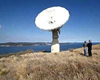
Canberra, Australia (SPX) Mar 12, 2007 Dozens of international satellite and modelling experts are meeting in Canberra today to discuss how to improve observations of the Earth to better understand and predict climate change, water availability, and natural disasters. CSIRO Marine and Atmospheric Research's Dr Alex Held, organiser of the two-day international meeting, says the researchers are planning to use a complex system of sensors, communication devices, storage systems and other technologies to take the Earth's pulse. "The Global Earth Observation System of Systems, or GEOSS, will benefit society in a number of ways, by providing better understanding of climate change and the water cycle, improved weather information, better natural disaster warnings, and ways to monitor and conserve biodiversity," Dr Held says. "Our aim is for GEOSS to bring together information from satellites, Earth system models, and other data to improve our understanding of the interactions between the ocean, atmosphere and land. Drawing on state-of-the-art technologies, GEOSS will assimilate streams of satellite data into computer models to improve predictions." Dr Held says that GEOSS aims to monitor continuously the state of the Earth to increase understanding and enhance prediction of the Earth system, and provide timely, quality, long-term, global information as a basis for sound decision making. "This topic is naturally of vital importance to Australia. The drought, recent bushfires and the IPCC report, among others, have sharpened everyone's attention on this issue," he says. The workshop is one of a series being held around the world in 2007 to give users and providers of Earth Observation information an opportunity to better understand GEOSS and its benefits for society. The Canberra workshop, held at CSIRO's Discovery Centre 8-9 March, will include presentations from invited speakers from Japan, USA and Europe. It is sponsored by: the Institute of Electrical and Electronics Engineers; US National Science Foundation and the Department of Education, Science and Training International Science Linkages Programme which was established under the Australian Government's Backing Australia's Ability - Building our Future through Science and Innovation package. The workshop is also being supported by CSIRO, the Bureau of Meteorology and University of NSW. It will be followed by the 2007 Ocean Surface Topography Science Team Meeting, to be held in Hobart, March 12-15. Community Email This Article Comment On This Article Related Links CSIRO Making money out of watching earth from space today Earth Observation News - Suppiliers, Technology and Application
 Canberra, Australia (SPX) Mar 06, 2007
Nearly 200 ocean and climate scientists will gather in Hobart this month for the first meeting in the Southern Hemisphere of the NASA/French Space Agency Ocean Surface Topography Science Team. The scientists specialise in using satellite altimeters to: |
|
| The content herein, unless otherwise known to be public domain, are Copyright 1995-2006 - SpaceDaily.AFP and UPI Wire Stories are copyright Agence France-Presse and United Press International. ESA PortalReports are copyright European Space Agency. All NASA sourced material is public domain. Additionalcopyrights may apply in whole or part to other bona fide parties. Advertising does not imply endorsement,agreement or approval of any opinions, statements or information provided by SpaceDaily on any Web page published or hosted by SpaceDaily. Privacy Statement |