|
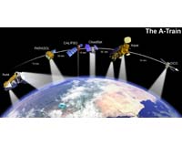
Seattle WA (SPX) Jun 13, 2006 NASA's Cloud-Aerosol Lidar and Infrared Pathfinder Satellite Observation spacecraft has begun gathering data from the Earth's atmosphere that are expected to become a key tool in unraveling just how much effect the reflectivity of clouds and tiny particles called aerosols are having on the planet's changing climate. University of Washington atmospheric scientists Robert Charlson and Theodore Anderson, co-investigators on the CALIPSO satellite's science team, said there are two key parts to the research: determining the effects of aerosols on climate in cloudy skies and in clear skies. "Much of the Earth is covered by broken clouds," Charlson said. "If you look down at any big patch of clouds, often you will see that it is really made up of broken clouds. That suggests that there could be an intermediate state between clear and cloudy conditions that has a considerable effect on climate, and it appears to be very sensitive to changes in aerosol levels." Aerosols are tiny particles suspended in the air, such as bits of dusty ash from volcanoes, smoke and haze from combustion, soil dust from desert storms and salt from evaporating sea spray. They float in the atmosphere, absorbing some sunlight and reflecting some back into space, but no one knows just how much effect they have globally. Charlson and Anderson said that remains one of the biggest unanswered questions about human-induced climate change. Scientists around the world hope to begin getting answers from CALIPSO. Its instruments have been preparing to collect detailed information. It is flying in a formation called the A-Train, a lineup of six satellites, each of which gathers different information about the Earth's atmosphere. CALIPSO is fourth in the formation, traveling just a few seconds behind CloudSat, which was launched on the same rocket and will provide radar data on thick clouds, complementing CALIPSO's lidar data on thin clouds and aerosols. Satellites for many years have produced pictures showing the Earth swathed in clouds. More recent instruments also identify aerosol plumes from dust storms, forest fires, industrial pollution and the like. While valuable, those data mainly provide a two-dimensional perspective, with no precise information about the altitude of the clouds and aerosols. CALIPSO will use lidar - a measuring tool like radar except that it employs laser light rather than radio waves - to measure the specific altitudes of clouds and aerosols to within about 100 feet, a groundbreaking advance on current satellite capabilities. "For the first time we will have access to global data telling us the altitudinal location of clouds and haze plumes in the atmosphere," Anderson said. "This is going to greatly advance the space-based study of aerosol-and-cloud interactions because we will have authoritative knowledge about whether the aerosol layer and the cloud layer are really at the same level in the atmosphere." Even a seemingly clear sky can have some cloudiness, but lidar can detect it even if it is not readily visible, Charlson said. He and Anderson will focus on determining how much of that sub-visible cloudiness there is around the world and what its properties are. From that information, they expect to eventually be able to establish the impact on climate change. If these unseen clouds, which they hypothesize are partly caused by high aerosol concentrations, cover only one-tenth of a percent of the Earth's atmosphere the effects would be negligible, Charlson said, but if the coverage is 1 percent it is a concern, and 10 percent coverage "would be a very big deal." "We suspect it is several percent," he said. Charlson noted that the satellite's lidar equipment uses an eye-safe laser that actually might be glimpsed in a hazy sky or on snow cover. It would be visible as a row of green dots about 250 feet across and 800 feet apart, but it could only be seen at night in a very dark sky, most likely from an airplane looking down at snow cover or clouds. To see it, a person would have to know precisely when the satellite will pass a certain spot, and would have to be watching very closely - the satellite will pass at more than 15,000 miles per hour and at an altitude of more than 430 miles. It also is possible that, in hazy conditions at night, the green laser beam might suddenly appear as a flashed row of vertical stripes in the sky. Lidar data have been collected previously - Charlson noted that the concept of using an orbiting lidar to gather atmospheric information was proven on a 1994 Space Shuttle mission - but it was a small amount of information and few scientists could use it. Scientists around the world will be able to use the CALIPSO data, he said. The satellite also is equipped with other scientific instruments that will collect information about the structure of clouds and aerosols. All of the information gathered will be important to those using computer models in trying to understand the mechanics of climate change and how it is likely to play out in the future. The mission, in development for more than 10 years, is a collaborative effort among NASA, the Centre National d'Etudes Spatiales of France, the Institut Pierre Simon Laplace in France, Hampton University in Virginia and Ball Aerospace & Technologies Corp. NASA's Langley Research Center is project manager and the Goddard Space Flight Center is providing support. Numerous scientists from around the world are co-investigators and science team members for CALIPSO. Community Email This Article Comment On This Article Related Links CALIPSO Earth Observation News - Suppiliers, Technology and Application
 Frederick MD (SPX) Jun 09, 2006
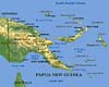
EarthData International announced Thursday it has been awarded a $16 million contract by the Australian government to produce the first-ever high-resolution image and terrain maps of Papua New Guinea. The Australian government is funding the project under a memorandum of understanding with the government of Papua New Guinea. |
|
| The content herein, unless otherwise known to be public domain, are Copyright 1995-2006 - SpaceDaily.AFP and UPI Wire Stories are copyright Agence France-Presse and United Press International. ESA PortalReports are copyright European Space Agency. All NASA sourced material is public domain. Additionalcopyrights may apply in whole or part to other bona fide parties. Advertising does not imply endorsement,agreement or approval of any opinions, statements or information provided by SpaceDaily on any Web page published or hosted by SpaceDaily. Privacy Statement |