|
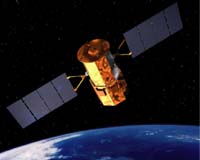
Boulder CO (SPX) Jun 27, 2006 Ball Aerospace and Technologies Corp. announced Monday it will design and build two cloud cameras for NASA's Glory mission under contract to Goddard Space Flight Center in Greenbelt, Md. The Glory mission is part of the U.S. Climate Change Science Program to improve understanding of what forces influence global environmental changes and how to predict those changes. Glory is a remote-sensing Earth-orbiting observatory scheduled to launch in 2008 for a three-year mission life. The mission will collect data on aerosols as well as radiant energy emitted by the Sun. Two instruments will be deployed in order to accomplish these objectives: the Aerosol Polarimetry Sensor, and the Total Irradiance Monitor. The Ball Aerospace cloud cameras complement the APS instrument, being developed by Raytheon Civil Space Programs. "These semi-custom CT-633 star tracker cameras have been the standard for Ball Aerospace missions for over a decade and include the wide-field camera onboard the recently launched CALIPSO mission," said David L. Taylor, the company's president and chief executive officer. He said since 1967, Ball Aerospace has designed and built six generations of star trackers. As part of the APS package, the cloud cameras will distinguish between cloud fields and clear scenes over land and the ocean, in order to collect data on chemical, microphysical, and optical properties, and spatial and temporal distributions of aerosols. At the same time, the TIM, being developed by the University of Colorado's Laboratory for Atmospheric and Space Physics in Boulder, will collect total solar irradiance data. Both instruments should help shed light on how human factors contribute to global warming compared to natural climate variability caused by the Sun. Community Email This Article Comment On This Article Related Links Glory Ball Aerospace Earth Observation News - Suppiliers, Technology and Application
 Ottawa, Ontario (SPX) Jun 26, 2006
Hon. Gary Lunn, Canada's Minister of Natural Resources, announced Friday a five-year, $2.4-million project to provide access to new, high-quality satellite images of Canada. Speaking at the 2006 Geomatics Leaders Forum in Ottawa, Lunn also announced that the improved and standardized satellite images will be available to all Canadians for free over the Internet. |
|
| The content herein, unless otherwise known to be public domain, are Copyright 1995-2006 - SpaceDaily.AFP and UPI Wire Stories are copyright Agence France-Presse and United Press International. ESA PortalReports are copyright European Space Agency. All NASA sourced material is public domain. Additionalcopyrights may apply in whole or part to other bona fide parties. Advertising does not imply endorsement,agreement or approval of any opinions, statements or information provided by SpaceDaily on any Web page published or hosted by SpaceDaily. Privacy Statement |