|
Ottawa, Ontario (SPX) Jun 26, 2006 Hon. Gary Lunn, Canada's Minister of Natural Resources, announced Friday a five-year, $2.4-million project to provide access to new, high-quality satellite images of Canada. Speaking at the 2006 Geomatics Leaders Forum in Ottawa, Lunn also announced that the improved and standardized satellite images will be available to all Canadians for free over the Internet. The newer and higher-quality images will be used for mapping, monitoring Canadian wetland areas and managing natural resources, and will support government decision and policy makers in the fields of public safety, health and the environment, as well as our northern and Aboriginal communities. "This investment will deliver more up-to-date and higher resolution images for our energy, mining and forestry industries," Lunn said. "Enhanced satellite data are part of this new government's commitment to securing long-term prosperity and competitiveness for these industries." Natural Resources Canada - NRCan - will coordinate and manage the project, ensure the quality of the data and act as liaison with the contractors, TELUS Corp. and Iunctus Geomatics Corp., which are supplying the satellite images. Other Government of Canada organizations involved in the project include Agriculture and Agri-Food, National Defence, Environment, Parks, Public Safety and Emergency Preparedness, and the national partnership initiative GeoConnections. Along with their provincial and territorial partners, they work under Canada's GeoBase initiative. Canadians will be able to access these new images through GeoBase, which is an approach to the management of geospatial data in Canada in which different levels of government work together to share the cost of providing up-to-date data. Through the GeoBase portal on the Internet, government and individual users have access to high-quality geospatial information at no cost and with unrestricted use. Community Email This Article Comment On This Article Related Links NRCan GeoBase Earth Observation News - Suppiliers, Technology and Application
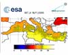 Paris, France (SPX) Jun 22, 2006
Before you pack your swimsuit and head to the sea this summer, you may want to check out the water's temperature with ESA's Medspiration heat map of all 2,965,500 square kilometers (1,144,985 square miles) of the Mediterranean. |
|
| The content herein, unless otherwise known to be public domain, are Copyright 1995-2006 - SpaceDaily.AFP and UPI Wire Stories are copyright Agence France-Presse and United Press International. ESA PortalReports are copyright European Space Agency. All NASA sourced material is public domain. Additionalcopyrights may apply in whole or part to other bona fide parties. Advertising does not imply endorsement,agreement or approval of any opinions, statements or information provided by SpaceDaily on any Web page published or hosted by SpaceDaily. Privacy Statement |