|
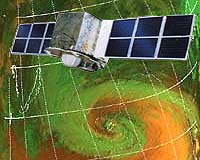
Beijing, China (XNA) Dec 06, 2006 Three "weather sentinels" in space will ensure accurate meteorological service for the 2008 Olympic Games, officials said yesterday. And by 2010, a navigation satellite system and a constellation of oceanic, environment, disaster and earthquake monitoring satellites will be in place. The plans were unveiled yesterday by Luo Ge, deputy chief of the China National Space Administration (CNSA) at a Beijing forum to mark the 50th anniversary of the country's space industry. In addition to the one in service, "we will launch a geo-stationary meteorological satellite soon, and four more of the series will follow in the next five years," Luo said at the forum sponsored by the Chinese Society of Astronautics. FY-2D (FY are the initials of the Chinese words for "wind and cloud"), will be placed in orbit within a week, Yang Jun, director of the National Satellite Meteorological Center, confirmed. "FY-2D will join the FY-2C satellite, which was sent into space in 2004; they will work as each other's back-up and to improve the accuracy of weather forecasts," Yang told China Daily from the Xichang Satellite Launch Center in Southwest China's Sichuan Province. Forecasters will then be able to get a "cloud map" of China every 15 minutes - half the time of the current intervals, he said by telephone. FY-2D will be in its "best service state" in 2008, when the 29th Olympic Games are held in Beijing, Yang said. FY-3, a polar-orbiting satellite, will be launched in the second half of next year; and compared with geo-stationary weather satellites, it offers pictures with resolutions 25 times as high, Yang said. The three FY satellites will also benefit people in the Asia Pacific as data is offered free to forecasters in the region, he said. In addition, the country plans to have in place a navigation satellite system covering China and its neighbors, CNSA Vice-Director Luo said. Space industry insiders said last month that two navigation satellites would be launched early next year as part of a plan to build a global positioning network. Luo said that breakthroughs are expected in satellite navigation and positioning systems, and plans are to have in place the Beidou-2 navigation and positioning system in five years. Other satellites set to be launched by 2010 include those for monitoring the environment, disasters, oceans and the earth's resources, according to Luo. In particular, China will begin developing an earthquake-monitoring satellite that can rapidly detect electromagnetic changes on the Earth's surface, he said. He did not specify when it would be ready. The official said scientists will strive to improve the reliability of satellites and extend their mission life. For example, in the coming five years, the lifespan of a communications and broadcast satellite will be increased from eight to 15 years; and the service period of earth observation satellites planned to be double the current two to three years, he said. In response to recent media reports that China is developing a reusable launch vehicle, Luo said his agency did not have such a plan for the next two to three decades. The country's ambitious plans suffered a setback when its first direct-to-home broadcast satellite launched in October did not function due to technical faults, and plans are afoot for a replacement. Source: Xinhua News Agency Community Email This Article Comment On This Article Related Links China National Space Administration Earth Observation News - Suppiliers, Technology and Application
 Paris, France (ESA) Dec 05, 2006
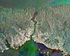
ESA PR 43-2006. Have you ever wanted to track natural events in progress, such as fires, floods and volcanic eruptions, or simply explore the planet through the eyes of a satellite? ESA has created a website, MIRAVI, which gives access to the most recently acquired images from the world's largest Earth Observation satellite, Envisat. |
|
| The content herein, unless otherwise known to be public domain, are Copyright 1995-2006 - SpaceDaily.AFP and UPI Wire Stories are copyright Agence France-Presse and United Press International. ESA PortalReports are copyright European Space Agency. All NASA sourced material is public domain. Additionalcopyrights may apply in whole or part to other bona fide parties. Advertising does not imply endorsement,agreement or approval of any opinions, statements or information provided by SpaceDaily on any Web page published or hosted by SpaceDaily. Privacy Statement |