|
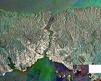
Paris, France (ESA) Dec 05, 2006 ESA PR 43-2006. Have you ever wanted to track natural events in progress, such as fires, floods and volcanic eruptions, or simply explore the planet through the eyes of a satellite? ESA has created a website, MIRAVI, which gives access to the most recently acquired images from the world's largest Earth Observation satellite, Envisat. MIRAVI, short for MERIS Images RApid VIsualisation, tracks Envisat around the globe, generates images from the raw data collected by Envisat's optical instrument, MERIS, and provides them online within two hours. MIRAVI is free and requires no registration. "ESA designed MIRAVI so that the public could have access to daily views of Earth. Naturally, scientists are already familiar with these data, but we thought these images would be interesting to everyone. Seeing the most recently acquired images of the planet will allow people to witness the magnificent beauty of Earth and become more knowledgeable about the environment," ESA's Director of Earth Observation Programmes Volker Liebig said. To enjoy the service, simply visit the MIRAVI website here and either browse the very latest images by clicking on the snapshots to the left, or view a specific location by either selecting an area on the world map or entering its geographic coordinates. MIRAVI also provides archived images since May 2006, searchable by date. Although the images are fascinating and provide the marvellous feeling that users are 'onboard the satellite', they are not suitable for scientific use. Scientists use MERIS products that exploit the instrument's 15 spectral bands and are generated with sophisticated algorithms. MIRAVI images use only a few spectral bands processed to appear the way the naked eye would see them. ESA's Envisat Mission Manager Henri Laur said: "The Envisat mission is a great success for Europe as a major source of information on the Earth system, including insights into factors contributing to climate change. Since its launch in 2002, Envisat continuously monitors the Earth's land, atmosphere, oceans and ice caps, thanks to its ten sophisticated instruments." Envisat circles the Earth in a polar orbit at an 800-km altitude, allowing MERIS to acquire global coverage every three days. MERIS measures the solar radiation reflected by the Earth, which means the sun must be present for MERIS to produce an image. Because the sun is low over Nordic areas during winter, images of Scandinavia, for example, are not currently available, except through the archive. The situation will reverse, however, from March onwards, and images of the area will be acquired daily. In contrast, Antarctica is visible for the next two months. Community Email This Article Comment On This Article Related Links MIRAVI Envisat Earth Observation News - Suppiliers, Technology and Application
 Pasadena, CA (SPX) Dec 04, 2006
To a non-scientist, the words 'radio occultation' might sound a little spooky. But this relatively simple NASA-developed technology at the heart of a new satellite network named Cosmic is proving to be a powerful new tool for weather and climate forecasting. |
|
| The content herein, unless otherwise known to be public domain, are Copyright 1995-2006 - SpaceDaily.AFP and UPI Wire Stories are copyright Agence France-Presse and United Press International. ESA PortalReports are copyright European Space Agency. All NASA sourced material is public domain. Additionalcopyrights may apply in whole or part to other bona fide parties. Advertising does not imply endorsement,agreement or approval of any opinions, statements or information provided by SpaceDaily on any Web page published or hosted by SpaceDaily. Privacy Statement |