|
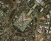
Canberra, Australia (SPX) Nov 09, 2004 DigitalGlobe announced that the Department of Urban Services in Canberra, Australia, is using QuickBird satellite imagery in its Internet mapping service, called Australian Capital Territory (ACT) Locate. The tool is used by urban planners, developers and resource managers for various mapping and spatial information applications pertaining to Canberra, Australia's capital. The Department of Urban Services' Geographic Information Management Unit purchased QuickBird imagery from Sinclair Knight Merz, a DigitalGlobe business partner, for incorporation into ACT Locate. The interactive mapping interface allows visitors to the Web site to search for and locate map features; create customized maps that display user-specified layers of information; retrieve information of interest such as the classification of a road or heritage site; measure distances; undertake spatial analysis queries and print maps. Displaying the most commonly used ground features, the maps are regularly updated with digital spatial data to reflect new or changing assets. The user simply selects an area of interest by either doing a "search and locate" by entering street address, land block details or place/feature name, or using the "create a map" feature to select and zoom into an area. The user may opt for a QuickBird satellite image-based background upon which maps and spatial information are overlaid. Showing such features as sidewalks, individual trees and parking lot lines, the 60-centimeter resolution of the QuickBird images puts the maps' lines and polygons into context and adds a new dimension to the user's visualization experience. The Australian government acquired DigitalGlobe QuickBird imagery over the ACT in 2002, and in 2004, the Department of Urban Services acquired a new set of images over the area. Both sets of images are available in ACT Locate to provide a unique and historical perspective. "In addition to its current application, the imagery will provide a valuable historical resource as the ACT physical environment changes with time," said Robert Twin, manager of the Geographic Information Management Unit. He cites as an example the extensive bushfires that devastated parts of Canberra in January 2003. "Since we have detailed satellite imagery from 2002, and again from 2004, we are able to conduct valuable analyses of the landscape before and after the fires," he said. According to Twin, a primary challenge in maintaining maps is the ability to keep the data current and promote its availability. "The use of digital data is crucial, because it means we can update the databases very rapidly and ensure users of the system that the information they are viewing is accurate." Twin said that the Department of Urban Services plans further acquisitions of DigitalGlobe imagery to complement its previous collections, as well as its large-scale aerial photography and lower resolution SPOT imagery. All supporting ACT Government organisations may access and use the imagery. The public availability of the data reduces the duplication of effort caused by each business unit acquiring its own version of the data, and makes it useful for visualisation and detailed analysis for numerous applications related to land and resource management. Sinclair Knight Merz orthorectified the QuickBird imagery to the Map Grid of Australia (MGA94) projection and produced imagery for each map scene. The satellite imagery is also available as a single mosaic that users can view as a background. Community Email This Article Comment On This Article Related Links Sinclair Knight Merz DigitalGlobe SpaceDaily Search SpaceDaily Subscribe To SpaceDaily Express Earth Observation News - Suppiliers, Technology and Application
 New York NY (SPX) Jan 11, 2006
The importance of remotely sensed data and technologies to support natural disasters has prompted attention and action in Washington. New initiatives and legislation authorizing appropriations to the remote sensing industry will be discussed at Strategic Research Institute's U.S. Commercial Remote Sensing Industry conference, scheduled for February 9-10, 2006 in Washington D.C. |
|
| The content herein, unless otherwise known to be public domain, are Copyright 1995-2006 - SpaceDaily.AFP and UPI Wire Stories are copyright Agence France-Presse and United Press International. ESA PortalReports are copyright European Space Agency. All NASA sourced material is public domain. Additionalcopyrights may apply in whole or part to other bona fide parties. Advertising does not imply endorsement,agreement or approval of any opinions, statements or information provided by SpaceDaily on any Web page published or hosted by SpaceDaily. Privacy Statement |