|
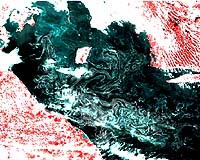
Espoo - Apr 21, 2002 Satellite sensors operating in the visible wavelength region are now in use for the monitoring of oceanic waters. For the first time ever, Finnish scientists have demonstrated the practical usability of satellite data for the simultaneous monitoring of water quality in large lake and coastal regions. The project was carried out by the Laboratory of Space Technology of the Helsinki University of Technology in cooperation with the Finnish Environment Institute. The attached figures show examples of water turbidity retrieval results obtained for Finnish lake and coastal regions by applying NASA's MODIS spectrometer data, with more to come from the ESA Envisat MERIS-spectrometer. These sensors with nearly global daily coverage employ visible wavelength channels of observation with spectral characteristics suited for water quality monitoring of turbid lakes and coastal regions. Turbidity is one of the essential water quality indicators as it describes, in practise, the integrated amount of algae biomass and suspended matter. The possibility to cover a large area in a single sweep is the most important improvement that can be obtained from using satellite data. The method also enables the detection of rapidly evolving phenomena such as algae blooms or oil spills and makes it possible to obtain information on regions which would normally not be monitored at all. Conventional discrete water quality sampling or the collection transect data with ship-borne observation systems never give a complete areal vision. These improvements are important aspects in boreal regions where the number of lakes is large and the quality of lake water is highly variable and sensitive to external pollution and climate change. In Finland, for example, the total number of lakes exceeding the minimum area of 0.01 km2 (1 ha) is about 60,000. MODIS data enables the monitoring of about 50 percent of the total Finnish lake area (16,000 km2). Monitoring the status of the Baltic Sea is another promising application for satellite sensors. The analysis of the data from MODIS and SeaWiFS spectrometers has shown that satellite observations are useful for the mapping of turbidity, chlorophyll concentration (algae biomass) and algae blooms. Particularly interesting results have been obtained for the Gulf of Finland using MODIS observations. The MODIS data-based turbidity maps have demonstrated the strong influence of the St. Petersburg region on the overall water quality in the Gulf of Finland. A good spatial resolution is required to monitor Baltic coastal regions and boreal forest/sub-arctic zone with fragmented water bodies, lakes and coastal zones comprising a small-scaled labyrinth of water and land areas. The spatial resolution of MODIS and MERIS is adequate even for the monitoring of the lakes of boreal forest zone: at its best 250 m and 300 m, respectively. Community Email This Article Comment On This Article Related Links Helsinki University of Technology SpaceDaily Search SpaceDaily Subscribe To SpaceDaily Express Earth Observation News - Suppiliers, Technology and Application
 New York NY (SPX) Jan 11, 2006
The importance of remotely sensed data and technologies to support natural disasters has prompted attention and action in Washington. New initiatives and legislation authorizing appropriations to the remote sensing industry will be discussed at Strategic Research Institute's U.S. Commercial Remote Sensing Industry conference, scheduled for February 9-10, 2006 in Washington D.C. |
|
| The content herein, unless otherwise known to be public domain, are Copyright 1995-2006 - SpaceDaily.AFP and UPI Wire Stories are copyright Agence France-Presse and United Press International. ESA PortalReports are copyright European Space Agency. All NASA sourced material is public domain. Additionalcopyrights may apply in whole or part to other bona fide parties. Advertising does not imply endorsement,agreement or approval of any opinions, statements or information provided by SpaceDaily on any Web page published or hosted by SpaceDaily. Privacy Statement |