|
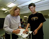
St Louis MO (SPX) Apr 17, 2007 An earthquake engineer at Washington University in St. Louis has successfully performed the first test of wireless sensors in the simulated structural control of a model laboratory building. Shirley J. Dyke, Ph.D., the Edward C. Dicke Professor of Civil Engineering and director of the Washington University Structural Control and Earthquake Engineering Laboratory, combined the wireless sensors with special controls called magnetorheological dampers to limit damage from a simulated earthquake load. Her demonstration is the first step toward implementing wireless sensors for structural control in real buildings and structures, enabling less manpower requirements and far less remodeling of existing structures. "This (wireless) is where structural control technology is going," said Dyke. "If you put a wired system in a building, the cost can be prohibitive. Soon, wireless sensors will become even cheaper, making this a nice application. It will be much easier putting wireless sensors into a building compared with taking walls out and installing wires and cables." Dyke and her colleagues recently published their results in the Proceedings of the 4th China-Japan-U.S. Symposium on Structural Control and Monitoring, Oct. 16-17, 2006. The work was funded by the National Science Foundation, Pfizer Inc. and Solutia Inc. The wireless sensors, about a square inch in size, are attached to the sides of buildings to monitor the force of sway when shaking, similar to an earthquake, occurs. The sensors are then transmitted to a computer program that translates the random units read by the sensors into units useful for the engineers and computer programmers. The computer sends a message to magnetorheological dampers, or MR dampers, that are within the building's structure to dampen the effect of the swaying on the structure. MR dampers act like shock absorbers for a building. Filled with a fluid that includes suspended iron particles, the MR dampers lessen the shaking by becoming solid when an electrical current (turned on by the computer, which has been alerted to the swaying by the sensors) is run through the MR dampers, aligning all of the iron particles. Dyke was the first civil engineer to demonstrate the use of MR damper technology for structural health monitoring and protection of buildings during seismic movement. She estimates that approximately 50 structures in Japan used wired sensors for structural control, with most of these structures using what is called a variable orifice damper. She said that both Japan and China feature one MR-damper controlled structure. Dyke said now that it's been shown that wireless sensors will work in a laboratory setting, the next step is to test them on a larger building in a bigger laboratory. "What we've learned from this implementation is going to allow us to extend to other concepts," Dyke said. "We can put sensors on for one application, such as control, and also have them do another function, such as damage detection. That way the wireless sensors can facilitate integration of multiple technologies." Community Email This Article Comment On This Article Related Links Bring Order To A World Of Disasters Bringing Order To A World Of Disasters A world of storm and tempest When the Earth Quakes
 Reston VA (SPX) Apr 16, 2007
For people caught in the throes of natural or technological disasters, rapid and accurate assessments of conditions on the ground are critical to saving lives and protecting property. Making such assessments just got easier. Two American commercial satellite imagery firms - DigitalGlobe and GeoEye - have joined forces with the U.S. Geological Survey (USGS) in support of the global team of space and satellite agencies that constitute the International Charter "Space and Major Disasters". |
|
| The content herein, unless otherwise known to be public domain, are Copyright 1995-2006 - SpaceDaily.AFP and UPI Wire Stories are copyright Agence France-Presse and United Press International. ESA PortalReports are copyright European Space Agency. All NASA sourced material is public domain. Additionalcopyrights may apply in whole or part to other bona fide parties. Advertising does not imply endorsement,agreement or approval of any opinions, statements or information provided by SpaceDaily on any Web page published or hosted by SpaceDaily. Privacy Statement |