 |
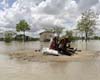
Ottawa (AFP) April 16, 2009 Winnipeg, the capital of Canada's western Manitoba province, on Thursday declared a state of emergency as a precaution against the rising Red River. In a statement, city officials said some 240 homes on the river side of a primary dike that protects Winnipeg from flooding were affected by the declaration, authorizing a quick evacuation if waters threaten any of them. As well, it gives sand-baggers and police access to private properties. Around the city, hundreds of residents have been evacuated as overland flash flooding was caused by frozen, saturated soil and crests lasting longer than usual, said a provincial bulletin. A voluntary evacuation order was also issued by several rural towns in Manitoba, it said. There are currently an estimated 975 square kilometers (97,500 hectares, 243,750 acres) of agricultural land under water in the flood zone, and flooding could last for "several weeks," said emergency officials. Thousands of people fled their homes last month in neighboring North Dakota as the flat prairie state was blanketed with snow and floods that were nine miles (14.5 kilometers) across in some points. Water was expected to be held back in Manitoba by a complex system of ring dikes around rural communities, hundreds of thousands of sandbags and a massive permanent ditch around the provincial capital, which is home to 650,000. Floating ice-breakers and steamers were also dispatched to break up any ice blocking water flows from North Dakota north to Lake Winnipeg and to thaw frozen culverts and drains across southern Manitoba. Flooding in the region occurs every spring, but the worst was in 1997, resulting in over 500 million dollars (405 million US) of damage in Manitoba, and in 1950 when 100,000 people were evacuated from the province. In 1969, the 47-kilometer (29-mile) Red River Floodway was opened, diverting part of the Red River's flow around the city of Winnipeg, in response to the 1950 flood. It was widened after the major 1997 flood. This year's flood was said by officials to be the second-worst on record since the 1800s, with expected flood levels only 0.6 meters (two feet) lower than the 1997 crest. Share This Article With Planet Earth
Related Links Bringing Order To A World Of Disasters When the Earth Quakes A world of storm and tempest
 Luanda (AFP) April 16, 2009
The death toll from deadly floods in southern Africa has risen to 145, aid workers and officials said Thursday, with hundreds of thousands of people affected by the high waters. |
|
| The content herein, unless otherwise known to be public domain, are Copyright 1995-2007 - SpaceDaily.AFP and UPI Wire Stories are copyright Agence France-Presse and United Press International. ESA Portal Reports are copyright European Space Agency. All NASA sourced material is public domain. Additional copyrights may apply in whole or part to other bona fide parties. Advertising does not imply endorsement,agreement or approval of any opinions, statements or information provided by SpaceDaily on any Web page published or hosted by SpaceDaily. Privacy Statement |
 del.icio.us
 Digg
Digg Reddit
 YahooMyWeb
 Google