|
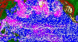
Pasadena - February 5, 1999 - Scientists, weather forecasters and the public take possession of a valuable stream of climate and meteorological observations this week, as the first calibrated measurements from NASA's SeaWinds instrument on the Quikscat satellite become available -- information that can improve weather forecasting around the world. "We're opening the tap on this global data to the world," said Dr. Michael Freilich, principal investigator on SeaWinds and a professor at Oregon State University, Corvallis. The measurements and data products show developing weather systems with unprecedented detail. "SeaWinds measurements of the direction and strength of the winds at the ocean surface give us new knowledge that, in combination with satellite measurements of clouds, temperature and other data, can be used for understanding how different weather systems and storms develop, and for predicting weather over the entire globe." The measurements also are crucial for understanding ocean currents, climate patterns, and the cyclical and anomalous variations that occur in those patterns, Freilich said. The heart of SeaWinds is a specially designed spaceborne radar instrument called a scatterometer. The radar operates at a microwave frequency that penetrates clouds. This, coupled with the satellite's polar orbit, makes the wind systems over the entire world's oceans visible to SeaWinds on a daily basis. The measurements provide detailed information about ocean winds, waves, currents, polar ice features and other phenomena, for the benefit of meteorologists, climatologists, oceanographers and mariners. SeaWinds was launched June 19, 1999, and engineers and scientists have successfully calibrated the satellite and verified the accuracy of its data over the past few months. "This new knowledge of winds over the oceans is essential for many oceanographic, meteorological and climate investigations, as well as for improving regional and global operational weather predictions," said climate researcher Dr. Ralph Milliff of the National Center for Atmospheric Research, in Boulder, CO. "SeaWinds data are eagerly anticipated by these research and operational communities." "Near real-time wind-vector measurements from SeaWinds represent a vast improvement in coverage over the generally data- sparse oceans," said SeaWinds science team member Dr. Paul Chang of the National Oceanic and Atmospheric Administration's National Environmental Satellite Data and Information Service. "SeaWinds data will be used operationally by marine forecasters and for numerical weather prediction models. These data promise to yield significant improvements in short-term warnings and forecasts and in medium- to long-range forecasts."
Email This Article Comment On This Article Related Links Space
 Calcutta, India (SPX) Dec 28, 2005
The successful launch Thursday of India's heaviest satellite from spaceport of Kourou in French Guyana may have boosted the country's space research efforts to yet another level, but it has also lifted the spirits of at least three Direct-To-Home televisions broadcasters, one of which has been waiting for years to launch its services in India. |
|
|
|
|
|
|
|
|
|
|
|
|
|
| The content herein, unless otherwise known to be public domain, are Copyright 1995-2006 - SpaceDaily.AFP and UPI Wire Stories are copyright Agence France-Presse and United Press International. ESA PortalReports are copyright European Space Agency. All NASA sourced material is public domain. Additionalcopyrights may apply in whole or part to other bona fide parties. Advertising does not imply endorsement,agreement or approval of any opinions, statements or information provided by SpaceDaily on any Web page published or hosted by SpaceDaily. Privacy Statement |