|
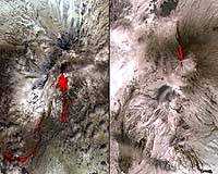
Greenbelt MD (SPX) May 03, 2007 One of the most volcanically active regions of the world is the Kamchatka Peninsula in eastern Siberia, Russia. It is not uncommon for several volcanoes to be erupting at the same time. On April 26, 2007, the Advanced Spaceborne Thermal Emission and Reflection Radioneter (ASTER) on NASA's Terra spacecraft captured these images of the Klyuchevskoy and Sheveluch stratovolcanoes, erupting simultaneously, and 80 kilometers (50 miles) apart. Over Klyuchevskoy, the thermal infrared data (overlaid in red) indicates that two open-channel lava flows are descending the northwest flank of the volcano. Also visible is an ash-and-water plume extending to the east. Sheveluch volcano is partially cloud-covered. The hot flows highlighted in red come from a lava dome at the summit. They are avalanches of material from the dome, and pyroclastic flows. With its 14 spectral bands from the visible to the thermal infrared wavelength region, and its high spatial resolution of 15 to 90 meters (about 50 to 300 feet), ASTER images Earth to map and monitor the changing surface of our planet. ASTER is one of five Earth-observing instruments launched December 18, 1999, on NASA's Terra spacecraft. The instrument was built by Japan's Ministry of Economy, Trade and Industry. A joint U.S./Japan science team is responsible for validation and calibration of the instrument and the data products. The broad spectral coverage and high spectral resolution of ASTER provides scientists in numerous disciplines with critical information for surface mapping, and monitoring of dynamic conditions and temporal change. Example applications are: monitoring glacial advances and retreats; monitoring potentially active volcanoes; identifying crop stress; determining cloud morphology and physical properties; wetlands evaluation; thermal pollution monitoring; coral reef degradation; surface temperature mapping of soils and geology; and measuring surface heat balance. The U.S. science team is located at NASA's Jet Propulsion Laboratory, Pasadena, Calif. The Terra mission is part of NASA's Science Mission Directorate. Email This Article
Related Links 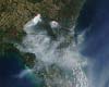 Greenbelt MD (SPX) May 03, 2007
A number of fires continue to burn in southeastern Georgia, as the Moderate Resolution Imaging Spectroradiometer (MODIS) on NASA's Terra satellite passed over, capturing this image on April 30. Active fire regions are indicated on the image with red pixels. Gusting winds and a lack of precipitation have added to the intensity of these fires, according to fire officials. Smoke continues to blow out over northern Florida, as seen above. |
|
| The content herein, unless otherwise known to be public domain, are Copyright 1995-2006 - SpaceDaily.AFP and UPI Wire Stories are copyright Agence France-Presse and United Press International. ESA PortalReports are copyright European Space Agency. All NASA sourced material is public domain. Additionalcopyrights may apply in whole or part to other bona fide parties. Advertising does not imply endorsement,agreement or approval of any opinions, statements or information provided by SpaceDaily on any Web page published or hosted by SpaceDaily. Privacy Statement |