|
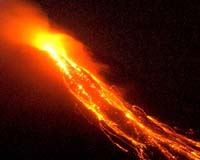
Matanag, Philippines (AFP) Jul 20, 2006 Villagers on the slopes of Mayon volcano prepared to evacuate Thursday as a series of minor eruptions and cloud of ash indicated it was building up for a major eruption soon, officials said. The cone-shaped 2,462-meter (8,077-foot) volcano southeast of Manila has been spewing lava since last week and all signs indicate it was preparing for a major explosive eruption within days or weeks, volcanologists said. "There were secondary explosions. A collapsed portion of the advancing lava caused an ash cloud of several hundred meters," scientist Ed Laguerta told AFP from the Philippine Institute of Volcanology and Seismology's observatory in Legaspi city near Mayon. He said alert level three of a five-step alert system remained hoisted over Mayon and nearby towns and villagers, meaning that residents should prepare for eventual evacuation. In the farming town of Matanag, which lies near the six-kilometer radius (four mile) permanent danger zone, residents have packed their things and were awaiting official word to evacuate. "We only have one life to live each, it's important to save that," said coconut farmer Romeo Nantes, 55, and a father of three. Nantes however said that he would be tending his farm until a major eruption occurs. Under the shade of a tree, fellow farmer Balasta Balangitan, 37, led his family and friends in planning an escape route as they watched the smouldering lava flow snake down the slopes. Balangitan said Matanag was among the towns devastated by Mayon's eruption in 2001, when several dozen people were killed. Mayon, about 300 kilometers (176 miles) southeast of Manila, is one of some 22 active volcanoes in the Philippines. It has erupted 47 times in recorded history, including in 1814, when it buried the town of Cagsawa killing an estimated 1,000 residents. Mayon's most recent major eruption was in 2001.
Source: Agence France-Presse Community Email This Article Comment On This Article Related Links A world of storm and tempest Bringing Order To A World Of Disasters When the Earth Quakes A world of storm and tempest
 Miami (AFP) Jul 18, 2006
The second tropical storm of the 2006 hurricane season formed Tuesday off the coast of North Carolina, the Miami-based National Hurricane Center reported. At 5 pm (2100 GMT) tropical storm Beryl was located 290 kilometers (180 miles) in the Atlantic southeast of Cape Hatteras, with winds of 64 kilometers (40 miles) per hour. |
|
| The content herein, unless otherwise known to be public domain, are Copyright 1995-2006 - SpaceDaily.AFP and UPI Wire Stories are copyright Agence France-Presse and United Press International. ESA PortalReports are copyright European Space Agency. All NASA sourced material is public domain. Additionalcopyrights may apply in whole or part to other bona fide parties. Advertising does not imply endorsement,agreement or approval of any opinions, statements or information provided by SpaceDaily on any Web page published or hosted by SpaceDaily. Privacy Statement |