|
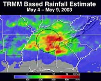
Greenbelt - May 14, 2003 Your local weather forecaster uses Doppler radar systems, covering U.S. regions, to estimate rainfall and flooding, but NASA research satellites can see rainfall worldwide. Data from NASA's Tropical Rainfall Measuring Mission (TRMM) satellite, along with information from other satellites, allows researchers to see how much rain is falling over most of the world every three hours. This capability enables scientists to daily map areas of potential flooding. These maps, available to the public on the Internet, will help water resource managers and scientists around the world by providing near-real time data of rainfall and flood potential. TRMM is considered a unique "rain gauge in the sky," because its instruments can look into clouds to determine rainfall, while other satellites can only see flooded areas after floods have occurred. Because of its extraordinary capability, TRMM is used to calibrate and fine-tune measurements of rainfall taken by other satellites, leading to current updated records on a global scale. Once baselines are established, researchers use the higher quality TRMM data wherever possible and fill in the gaps with data from other satellites to get a more complete picture of rainfall around the world. "This ability to detect potential floods is extremely useful for disaster monitoring," said Robert Adler, TRMM Project scientist at the Goddard Space Flight Center, Greenbelt, Md. "The rainfall maps are also useful in assessing the state of crops in remote regions, especially in the tropics," he said. Maps that show areas of potential floods use precipitation radar data and high-resolution measurements of water content of clouds made by microwave radiometers. The maps span the Earth from 50 degrees north latitude to 50 degrees south latitude (an area just north of the U.S.-Canadian border and south to the tip of Argentina). There are three variations of the rainfall accumulation maps, including 24-hour maps showing areas where more than 35 mm (1.37 inches) of rain has accumulated; maps with three-day accumulations of more than 100 mm (3.93 inches); and maps depicting areas with weeklong accumulations of more than 200 mm (7.87 inches). Another map product, updated every three hours, shows a global snapshot of rainfall. A seven-day "movie loop" of the images allows users to track storms as they travel over land and oceans around the globe. Researchers use these near- global rainfall maps to monitor formation and dissipation of El Nino/Southern Oscillation conditions, soil moisture, and ocean salinity. These maps also are useful to water resource managers and farmers around the world. The Adler led team of NASA scientists produced these TRMM rainfall and flood potential maps. The maps merge data from the TRMM Microwave Imager Precipitation Radar with information from other microwave satellites and geosynchronous weather satellite infrared data. Exploiting the strengths of multiple data sources increases the accuracy of the maps. TRMM is a joint U.S.-Japanese mission and part of NASA's Earth Science Enterprise, a long-term research program designed to study the Earth's land, oceans, air, ice and life as a total system. The TRMM satellite was launched on November 27, 1997. Community Email This Article Comment On This Article Related Links TRMM rain and flood maps SpaceDaily Search SpaceDaily Subscribe To SpaceDaily Express Dirt, rocks and all the stuff we stand on firmly
 Paris (ESA) Jan 12, 2006
Using the ESA Cluster spacecraft and the NASA Wind and ACE satellites, a team of American and European scientists have discovered the largest jets of particles created between the Earth and the Sun by magnetic reconnection. This result makes the cover of this week's issue of Nature. |
|
| The content herein, unless otherwise known to be public domain, are Copyright 1995-2006 - SpaceDaily.AFP and UPI Wire Stories are copyright Agence France-Presse and United Press International. ESA PortalReports are copyright European Space Agency. All NASA sourced material is public domain. Additionalcopyrights may apply in whole or part to other bona fide parties. Advertising does not imply endorsement,agreement or approval of any opinions, statements or information provided by SpaceDaily on any Web page published or hosted by SpaceDaily. Privacy Statement |