|
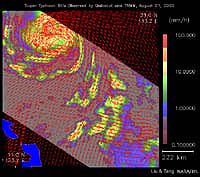
Pasadena - August 24, 2000 - As super Typhoon Bilis, equal in strength to a category 5 hurricane, bears down on Taiwan, images taken by two NASA instruments on August 21, 2000, show the massive storm's most devastating components: rain and wind. Conventional satellite data provide imagery of the clouds at the top of a storm. These images, however, were created by combining data from two NASA instruments capable of looking through a storm's clouds and seeing what is going on at the surface. These two instruments passed over the same location about one hour apart. The images show the surface winds, measured by SeaWinds on QuikSCAT's radar scatterometer. The wind data are superimposed on rainfall measurements made by the microwave imager on the Tropical Rain Measuring Mission satellite (TRMM).
Email This Article Comment On This Article Related Links Space
 Calcutta, India (SPX) Dec 28, 2005
The successful launch Thursday of India's heaviest satellite from spaceport of Kourou in French Guyana may have boosted the country's space research efforts to yet another level, but it has also lifted the spirits of at least three Direct-To-Home televisions broadcasters, one of which has been waiting for years to launch its services in India. |
|
|
|
|
|
|
|
|
|
|
|
|
|
| The content herein, unless otherwise known to be public domain, are Copyright 1995-2006 - SpaceDaily.AFP and UPI Wire Stories are copyright Agence France-Presse and United Press International. ESA PortalReports are copyright European Space Agency. All NASA sourced material is public domain. Additionalcopyrights may apply in whole or part to other bona fide parties. Advertising does not imply endorsement,agreement or approval of any opinions, statements or information provided by SpaceDaily on any Web page published or hosted by SpaceDaily. Privacy Statement |