|
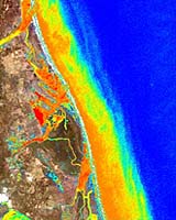
Billerica MA (SPX) Jan 14, 2005 Specialized analysis of recent satellite imagery of a tsunami-ravaged section of Porto Nova, India, near Sri Lanka, has revealed a devastating impact to local water quality. According to Applied Analysis of Billerica, Massachusetts, contaminated sediment has impacted a large number of inland water bodies in the area and is evident more than two kilometers offshore in the Indian Ocean. Using a proprietary analysis process developed initially for military applications, Applied Analysis has processed a recent IKONOS satellite image of the region clearly showing the impacted areas. This advanced technology measures clarity of the water, enabling remote identification of potential clean water sites. Additionally, the company processed images for suspended mineral and chlorophyll content, important indicators of fresh water quality. The processed images of Porto Nova clearly show the impact to the water quality in the area. As additional satellite imagery becomes available, this technology will be helpful in the near term by identifying potential clean water sites, as well as those areas with the highest concentrations of likely contaminants. In the weeks and months ahead, the same process can be used to determine the overall impact on aquaculture zones and, in offshore waters, the extent of sediment and debris that will most certainly affect the reefs and other living organisms so prevalent in the area. Applied Analysis President Carey Erdman commented, "Clearly the tsunami caused serious ecological damage, but how much damage, particularly to water resources, is unknown. This technology will enable rapid prioritization and streamlining of the clean-up and recovery efforts, as well as provide an early indication of the likely long-term impact on the food and water supply." Community Email This Article Comment On This Article Related Links Applied Analysis SpaceDaily Search SpaceDaily Subscribe To SpaceDaily Express Earth Observation News - Suppiliers, Technology and Application
 New York NY (SPX) Jan 11, 2006
The importance of remotely sensed data and technologies to support natural disasters has prompted attention and action in Washington. New initiatives and legislation authorizing appropriations to the remote sensing industry will be discussed at Strategic Research Institute's U.S. Commercial Remote Sensing Industry conference, scheduled for February 9-10, 2006 in Washington D.C. |
|
| The content herein, unless otherwise known to be public domain, are Copyright 1995-2006 - SpaceDaily.AFP and UPI Wire Stories are copyright Agence France-Presse and United Press International. ESA PortalReports are copyright European Space Agency. All NASA sourced material is public domain. Additionalcopyrights may apply in whole or part to other bona fide parties. Advertising does not imply endorsement,agreement or approval of any opinions, statements or information provided by SpaceDaily on any Web page published or hosted by SpaceDaily. Privacy Statement |