|
Sunnyvale - Jan 21, 2004 Trimble has been awarded two contracts from the U.S. Air Force (USAF) to provide Global Positioning System (GPS) surveying and mapping systems. The GPS equipment will be used as part of the GeoBase Civil Engineering Program for worldwide surveying and construction projects. The contracts are valued at approximately $5 million. Under the contract, Trimble will supply GPS Total Station 5700 GPS surveying systems, GPS Pathfinder Pro XRS mapping systems, GeoExplorer CE series GPS handheld receivers, and training. The systems will be used to collect accurate position data to map USAF Base installation assets as well as build base camps and airfields worldwide. The integration of position data with asset information will assist in managing the USAF Base installation's physical infrastructure. In addition, the systems may be used to assist during natural disasters and with community service projects. The GeoBase program represents a major paradigm shift in how geospatial information resources are being acquired, implemented, exploited, and sustained on USAF installations around the world. GeoBase aims to deliver a comprehensive, integrated geospatial information infrastructure supporting "Blue Force" basing requirements. With the vision of "One Installation...One Map", GeoBase will give commanders a decision support tool providing a common, georeferenced view of all their infrastructure assets to answer questions such as -- what is it, where is it, and what's around each installation. The Trimble GPS Total Station 5700 is an easy-to-use modular system. It provides surveyors with total flexibility, using different set-up configurations for all types of surveying tasks. The receiver can be configured with all the components and mounted on a lightweight range pole or worn with a belt pouch. The system can also be mounted on a tripod, vehicle, boat, ATV or placed in a backpack. The systems include dual-frequency 5700 GPS receivers, ruggedized handheld TSCE(TM) controllers, Trimble Geomatics Office(TM) processing software, radios, antennas and accessories which include back packs, tripods, transit cases and batteries. Each system can be deployed as either a precision mobile survey unit or as a reference station to provide Real-Time Kinematic (RTK) data signals to the mobile unit. With the addition of the 5700 RTK systems, the USAF survey equipment now includes GPS, servo and robotic total stations from Trimble. At the heart of the system is a low-power, GPS receiver, which provides higher speed, longer battery life, better satellite tracking and higher precision in extreme environments. The GPS receiver also includes an internal radio modem and the extended Real-time Kinematic (eRTK(TM)) technology, which can cover areas up to four times larger than conventional RTK. The 5700 receiver is housed in an extremely rugged, space-age magnesium alloy case which is lighter than aluminum, yet 30% stronger. The receiver weighs less than 1.4kgs. (3 lbs), including batteries for a full day's work, internal radio, radio antenna and internal charger. In addition, the GPS system works with the Zephyr(TM) and Zephyr Geodetic(TM) antennas, both using the patented Trimble 4-point antenna feed technology. The Zephyr Geodetic antenna features the patented Trimble Stealth(TM) ground plane technology, which mitigates multipath signals. GPS enabled GIS data collection and maintenance allows timely data availability which supports effective decision-making. Organizations or agencies that require accurate information that is tied to location can benefit from the productivity provided by GPS technology. Cities, government agencies, scientific organizations, utility companies, and the military around the world use GIS data collection and data maintenance systems to stay up-to-date. Trimble's complete range of products provides the accuracy, flexibility, and ease of use required by mapping and GIS professionals. The GeoExplorer CE series is a new tool for GPS/GIS data collection and mobile GIS applications. The versatile, rugged GPS CE handhelds combines the power of Microsoft's Windows CE platform and a high performance Trimble GPS receiver with integrated Wide Area Augmentation System (WAAS) capability -- all in a lightweight handheld. Trimble's GPS Pathfinder systems are used for data collection, update, and processing. They integrate seamlessly with industry-standard GIS systems, providing users with timely, accurate data for decision-making. The GPS Pathfinder family includes GPS receivers, antennas, field software and office software. Community Email This Article Comment On This Article Related Links Trimble SpaceDaily Search SpaceDaily Subscribe To SpaceDaily Express GPS Applications, Technology and Suppliers
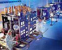
 Cheltenham, England (SPX) Jan 09, 2006
Marotta UK is pleased to announce that it designed, developed and qualified equipment for the cold gas propulsion systems on board the Galileo GIOVE-A, part of Europe's Galileo navigation program, successfully launched by Surrey Satellite Technology (SSTL). |
|
| The content herein, unless otherwise known to be public domain, are Copyright 1995-2006 - SpaceDaily.AFP and UPI Wire Stories are copyright Agence France-Presse and United Press International. ESA PortalReports are copyright European Space Agency. All NASA sourced material is public domain. Additionalcopyrights may apply in whole or part to other bona fide parties. Advertising does not imply endorsement,agreement or approval of any opinions, statements or information provided by SpaceDaily on any Web page published or hosted by SpaceDaily. Privacy Statement |