|
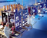
Nashville - Apr 20, 2004 Trimble reports that the company's next generation R-Track technology was used to verify the interoperability of the new Block IIR-M Global Positioning System (GPS) satellite payload with current and modernized survey equipment. The Trimble R7 RTK GPS system is the only L2C-ready survey equipment currently available to test the new satellite signal by the Joint Program Office (JPO), which manages the Navstar GPS system. The Trimble R7 system, which can take advantage of today's GPS satellite and future L2C signal, successfully showed that the Block IIR-M satellite's data can be acquired, tracked and logged. The announcement was made today at the American Congress of Surveying and Mapping/Tennessee Association of Professional Surveyors (ACSM/TAPS) Conference and Technology Exhibition. The Block IIR-M GPS satellites are part of the Department of Defense's (DOD) GPS Modernization Program. GPS Modernization will add two new signals and increased signal power for civilian users over several years -- as well as advanced features and new signals for military use. Built earlier, the IIR-M satellites have been 'modernized' with the new civilian L2C code as well as two new military codes; the DOD plans to modernize up to 12 Block IIR satellites currently in storage. The test took place at ITT Industries in New Jersey where the Block IIR-M satellites are being tested before launch. The first Block IIR-M satellite, scheduled for launch within the next 12 months, will send a new civil GPS code on the L2 signal, referred to as the L2C signal. L2C-ready civilian GPS receivers will be able to track the new signal code directly, yielding improved reception compared with previous indirect reception techniques. Various tests were run with the Trimble R7 survey system. JPO used a commercial simulator to imitate the GPS constellation and generate current signals. The simulated constellation was then coupled with the output from an IIR-M satellite; this made it possible to track and use the current signals together with a Block IIR-M satellite and produce a solution. Community Email This Article Comment On This Article Related Links Trimble SpaceDaily Search SpaceDaily Subscribe To SpaceDaily Express GPS Applications, Technology and Suppliers
 Cheltenham, England (SPX) Jan 09, 2006
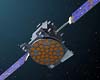
Marotta UK is pleased to announce that it designed, developed and qualified equipment for the cold gas propulsion systems on board the Galileo GIOVE-A, part of Europe's Galileo navigation program, successfully launched by Surrey Satellite Technology (SSTL). |
|
| The content herein, unless otherwise known to be public domain, are Copyright 1995-2006 - SpaceDaily.AFP and UPI Wire Stories are copyright Agence France-Presse and United Press International. ESA PortalReports are copyright European Space Agency. All NASA sourced material is public domain. Additionalcopyrights may apply in whole or part to other bona fide parties. Advertising does not imply endorsement,agreement or approval of any opinions, statements or information provided by SpaceDaily on any Web page published or hosted by SpaceDaily. Privacy Statement |