|
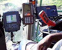
for NASA Science News Neal Isbell prepares for his workday by loading his trusty pickup truck with the everyday essentials of farming: his cap, jacket, extra boots, a box lunch and his dog. And don't forget the laptop computer and a GPS receiver. "The laptop is now an essential part of our farming operation and I have a hard time keeping the dog from stepping on it," laughs Isbell. Isbell's family has been farming in northern Alabama for six generations -- but Isbell isn't running the farm as his forefathers did. He is one of a new generation of growers called "precision farmers." Precision farmers use data from satellites and high-flying aircraft to pinpoint problems with drainage, insects and weeds. They learn where fertilizers are needed -- and where they're not needed. They discover pests -- and spray only the infested areas. It's a remarkably "green" approach to farming that is both friendly to the environment and profitable to the farmer. "We're seeing some real savings in fertilizer applications," says Isbell, "and our fields are more uniformly productive than ever." Despite the advantages of precision farming, however, growers like Isbell remain uncommon. Many farmers simply don't know the technology exists, while others aren't convinced that it makes economic sense. Hoping to change that, NASA launched a program in 1999 called Ag20/20 -- an industry-government partnership led by NASA and the United States Department of Agriculture (USDA). "We're educating farmers about precision farming technology and we're collecting hard evidence that it pays for itself," explains Rodney McKellip, who directs the program from NASA's Stennis Space Center in Mississippi. Ag20/20 partners include the National Corn Growers Association, the National Cotton Council, the United Soybean Board and the National Association of Wheat Growers. Ag20/20 has dealt mainly with corn, soybeans, cotton and wheat, "because those are the four biggest agricultural commodities in the United States," says McKellip. This year, though, the program will "branch out" to include orchards in Florida and Washington, and perennials -- like cranberries and blueberries -- in the Northeast. Precision farmer Neal Isbell is a cotton grower with 4200 acres under his care. Such expansive farms are difficult to canvass simply by walking or driving across the fields; they benefit from the "big picture" a satellite or an aircraft can provide. "We use commercial satellites, like Ikonos and QuickBird," says McKellip, "as well as cameras mounted in aircraft." Sometimes NASA lends one of its own aircraft to the cause, but more often Ag20/20 encourages precision farming teams to use local flying services -- for example, Agri-Vision, a company in Columbus, Indiana, that collects digital images for agriculture in the Midwest. The cameras used for precision farming are not ordinary. They can photograph a field as it appears not only at wavelengths of visible light, which the human eye can see, but also at near-infrared and thermal infrared wavelengths. "We find that near-infrared images are often the most useful for diagnosing the condition of a crop," notes McKellip. Charles Hutchinson, of NASA Headquarters' Office of Earth Science, explains: Plants are good reflectors of near-infrared rays from the Sun. When the cells in leaves are healthy and turgid, they scatter near-infrared radiation in all directions. But when leaves begin to wilt -- because of stress caused by arid soil, pests or disease -- they become less reflective. "Stressed out" crops appear as darker-than-average spots in near-infrared images. "The near-infrared part of the electromagnetic spectrum is more sensitive than visible light [to small changes in crop vitality]," continues McKellip. As a result, near-infrared images can pinpoint trouble spots before they become obvious to the human eye. Once trouble spots are identified, a farmer might send out a human scout to see what's wrong. For example, Neal Isbell recently dispatched scouts across his farm to collect soil samples. "We used GPS receivers to keep track of our positions," says Isbell. The samples revealed a pH imbalance in some areas -- easily corrected by adding lime to the soil. Farmers have long known that growing conditions weren't the same at all places on their farms, yet until recently they had little choice but to treat their fields uniformly with "one size fits all" solutions. "These days nearly all new farm equipment has, as options, computerized controllers and GPS-guided navigation," says McKellip. "These devices have the ability to turn a sprayer, for example, on and off as it passes through a certain area of a field. This wasn't the case ten years ago." One of the most important challenges for precision farming is getting data while it's still fresh. Farmers with rapidly growing crops need to know the state of their fields now, not days or weeks ago. Aircraft are still the best in this regard. McKellip explains: "An airplane can take pictures any time the weather is clear, but a satellite only passes over a field at a certain time on certain days. We typically get computer-processed data from airborne systems back to the farmer in as little as 24 hours." Satellite images, which require more time to downlink and process, can take from 2 to 7 days to reach a farmer. Such delays won't be a problem forever, though. "Technology is advancing quickly and more of these commercial satellites are being launched each year," he added. Indeed, perhaps only a decade or so hence, Isbell will climb down from his tractor holding a palm-sized computer in direct contact with Earth orbiting satellites. The screen will reveal a map of crop stresses only minutes old. A few buttons punched ... and automated systems rush to trouble spots spraying precise amounts of pesticides, fertilizer, and water. Satisfied, he'll glance around his burgeoning field. "But wait," he wonders, suddenly puzzled, "where did my dog go?" Fingers snap. "I must've forgot his GPS collar again!" Perhaps some things will never change.... Community Email This Article Comment On This Article Related Links Precision Agriculture Information SpaceDaily Search SpaceDaily Subscribe To SpaceDaily Express The latest information about the Commercial Satellite Industry
Globalstar recently announced that it has signed a definitive agreement to acquire 100% of the stock of Globalstar Americas Telecommunications, Globalstar Americas Holdings, and Astral Technologies Investments. |
|
| The content herein, unless otherwise known to be public domain, are Copyright 1995-2006 - SpaceDaily.AFP and UPI Wire Stories are copyright Agence France-Presse and United Press International. ESA PortalReports are copyright European Space Agency. All NASA sourced material is public domain. Additionalcopyrights may apply in whole or part to other bona fide parties. Advertising does not imply endorsement,agreement or approval of any opinions, statements or information provided by SpaceDaily on any Web page published or hosted by SpaceDaily. Privacy Statement |