 |
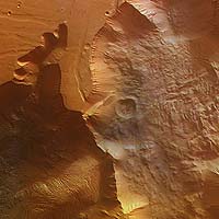
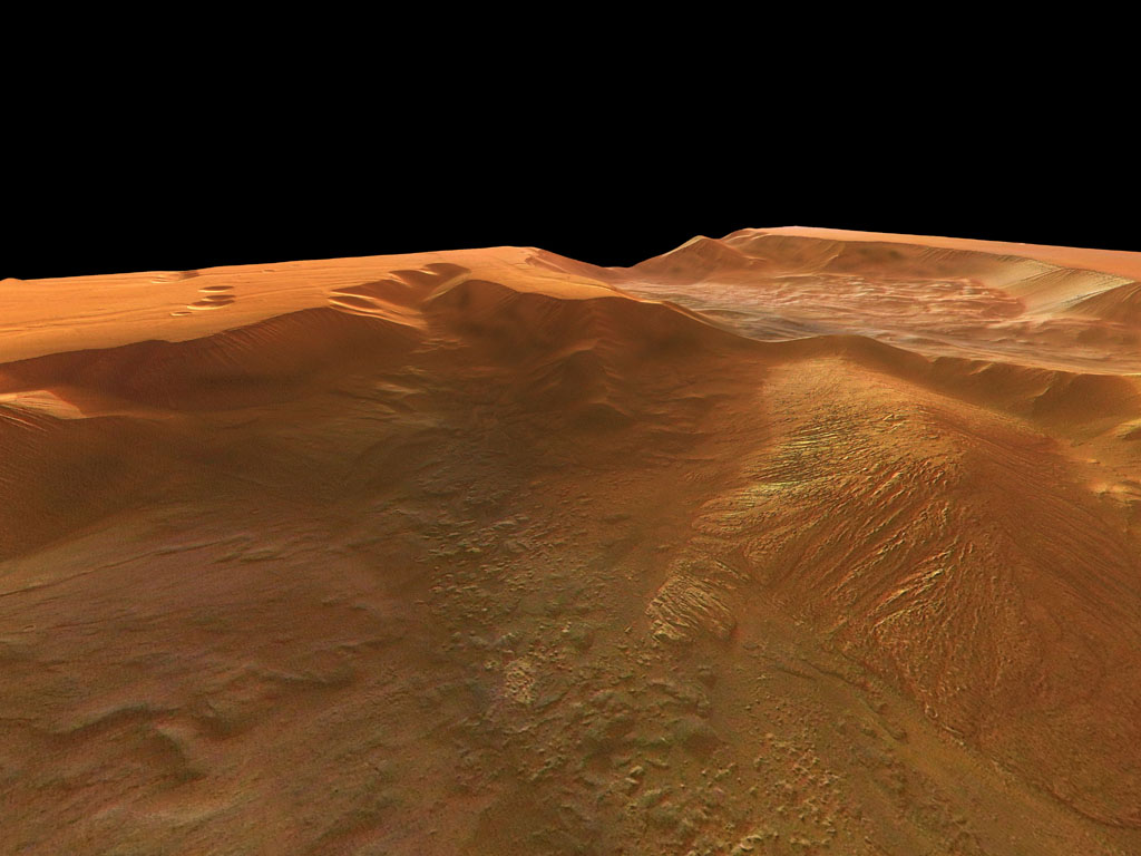
Paris (ESA) May 02, 2005 These images, taken by the High Resolution Stereo Camera (HRSC) on board ESA's Mars Express spacecraft, show part of Tithonium Chasma, a major trough at the western end of the Valles Marineris canyon on Mars. The images were taken during orbit 887 with a ground resolution of approximately 13 metres per pixel. The displayed region (pictured) is located at the beginning of the canyon system at about latitude 5� South and longitude 280� East. North is to the right of the image. Tithonium Chasma extends roughly from east to west and runs parallel to Ius Chasma. It ranges from approximately 10 to 110 kilometres wide, narrows in an easterly (top to bottom) direction and has a maximum depth of about 3.5 to 4 kilometres. The colour image covers the eastern part of Tithonium Chasma. Along the slopes of the trough (centre), linear features due to erosion are visible. At the base of the northern wall (on the right of the black and white image), an apron of material has a longitudinal ridge pattern and may have been caused by a large landslide (see close-up, right). Dune fields are scattered throughout the trough, including the north-east portion of a crater. A string of depressions on the plains in the south-west of the image may be caused by surface collapse. These features are common to this region and extend parallel to Valles Marineris. Nearby, prominent linear features are visible and may be faults associated with the formation of the Tharsis Rise, located to the west of Valles Marineris and extending to a height of 8 to 10 kilometres. Some of these faults can be seen faintly extending into the trough. In the eastern part of the trough, an interesting hill exhibits linear features. These structures are highlighted in the following close-up and perspective views and could have been caused by fluvial or 'aeolian' (wind-related) erosion. The darker material to the south of this hill is thought to be underlying material that has been exposed by wind erosion. By cutting deep into the Martian surface, this area of Valles Marineris provides a window into geological and climatic history of the planet. Valles Marineris has had a complex evolution and has been shaped by tectonic, volcanic and glacial processes, as well as possibly fluvial or aeolian erosion. Data from the HRSC, coupled with information from the other instruments on ESA's Mars Express and other missions, will provide new insights into the geological evolution of the Red Planet and also pave the way for future missions. The colour images were processed using the HRSC nadir (vertical view) and three colour channels. The perspective views were calculated from the digital terrain model derived from the stereo channels. The 3D anaglyph image was created from the nadir channel and one of the stereo channels. Stereoscopic glasses are needed to view the 3D image. Image resolution has been decreased for use on the internet. Community Email This Article Comment On This Article Related Links Mars Express at ESA SpaceDaily Search SpaceDaily Subscribe To SpaceDaily Express Mars News and Information at MarsDaily.com Lunar Dreams and more
 Pasadena CA (JPL) Jan 09, 2006
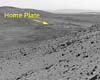
Last week Spirit completed robotic-arm work on "El Dorado." The rover used all three of its spectrometers plus the microscopic imager for readings over the New Year's weekend. |
|
| The content herein, unless otherwise known to be public domain, are Copyright 1995-2006 - SpaceDaily.AFP and UPI Wire Stories are copyright Agence France-Presse and United Press International. ESA PortalReports are copyright European Space Agency. All NASA sourced material is public domain. Additionalcopyrights may apply in whole or part to other bona fide parties. Advertising does not imply endorsement,agreement or approval of any opinions, statements or information provided by SpaceDaily on any Web page published or hosted by SpaceDaily. Privacy Statement |
