|
Paris (ESA) Feb 08, 2005 The results obtained over the last ten years thanks to the interpretation of data from remote sensing satellites have demonstrated the possibilities afforded by space-based techniques for research and applications in oceanography. Encouraging results leading to operational use (GEOSS and GMES initiatives) have been established in research and environmental studies and also in areas more closely connected with industry such as fishing. Background The purpose of the conference "New space services for maritime users: the impact of satellite technology on maritime legislation", which will be held in Paris at the UNESCO on 21-23 February 2005, is to bring together scientific and technical experts, the legal and administrative experts and the user community to express their needs and possible solutions, look at what is available already and what new developments will be arising in the near future, review the status of implementation in the light of technical developments and see what new legislation at regional and national level may be needed to implement and expand the recommendations made at the Vigo Conference. This Symposium indeed follows the conference jointly organised by EURISY and INTA in Vigo, Spain, in 2003, that formulated a series of Conclusions and Recommendations addressed to the decision-makers of the European Union, its Member States and relevant international organisations. These Recommendations included the development of an appropriate legal framework including legislation admitting space-based information in court, and ensuring better law enforcement across national boundaries. The Symposium focuses on two objectives:
Assessing the state of the art Remote sensing satellites are generating information for the benefit of maritime users: transport companies and operators, public authorities, coast-guards and fisheries. These data are merged with data from other sources: satellite navigation systems (GPS, Galileo) and traditional maritime security and safety data gathering. Satellite communication links connect the data sources in real-time.
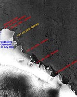
ASAR assists Antarctic rescue mission The symposium will focus on scientific research in the maritime milieu and will contribute to identify the space facilities and systems, which could be used in the future in order to control the compliance with legislation, and the way they are integrated into global information systems like a global automatic identification system (AIS), vessel traffic monitoring systems, long range identification and tracking of vessels (LRIT), or systems aimed at mapping underwater obstacles, preventing collisions, monitoring living resources of the ocean, prospecting new non-renewable resources.
A new legal framework on Maritime transport in Europe New space services can be provided in the legal context of maritime transport. In Europe maritime transport policy is oriented towards Safety, Security, Efficiency and Environment in Shipping and the use of space instruments to enhance and control its enforcement. Other countries like Canada and USA are thinking along the same lines. The Symposium will reflect the activities to be developed in the coming years by the space actors and users for the benefit of the public authorities in charge of the application of the regulation as well as the expectations of the other users of space services.
Practical Information The Symposium "New space services for maritime users: the impact of satellite technology on maritime legislation" , co-organised by EURISY and the IAF, will be held in Paris from 21 to 23 February, at UNESCO Headquarters. It is cosponsored by ESA, UNESCO, CNES, EUMETSAT and EADS. Registrations form and a detailed programme can be downloaded from the EURISY and IAF websites. Press interviews will be organised at UNESCO, on 23 February.
Email This Article Comment On This Article Related Links Eurisy IAF EC GMES site SpaceDaily Search SpaceDaily Subscribe To SpaceDaily Express Earth Observation News - Suppiliers, Technology and Application
 New York NY (SPX) Jan 11, 2006
The importance of remotely sensed data and technologies to support natural disasters has prompted attention and action in Washington. New initiatives and legislation authorizing appropriations to the remote sensing industry will be discussed at Strategic Research Institute's U.S. Commercial Remote Sensing Industry conference, scheduled for February 9-10, 2006 in Washington D.C. |
|
| The content herein, unless otherwise known to be public domain, are Copyright 1995-2006 - SpaceDaily.AFP and UPI Wire Stories are copyright Agence France-Presse and United Press International. ESA PortalReports are copyright European Space Agency. All NASA sourced material is public domain. Additionalcopyrights may apply in whole or part to other bona fide parties. Advertising does not imply endorsement,agreement or approval of any opinions, statements or information provided by SpaceDaily on any Web page published or hosted by SpaceDaily. Privacy Statement |