|
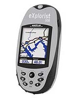
Las Vegas NV (SPX) Jan 06, 2005 Thales continues to rewrite the rulebook for handheld GPS when it announced Wednesday the CES debut of three additions to its breakthrough Magellan eXplorist line of compact, powerful, yet easy-to-use receivers. Complete with built-in mapping, the Magellan eXplorist 400, eXplorist 500 and eXplorist 600 are the first handheld GPS receivers to deliver PC-like file management, rechargeable lithium-ion batteries and a PC application designed specifically for transferring geocache information from the Internet to the eXplorist for the popular web-based outdoor activity called geocaching. These new eXplorist handhelds represent the definitive GPS guidance solution to meet the more diverse navigation needs of today's consumer - both in the city and the outdoors. The complete Magellan eXplorist line of six receivers delivers more advanced features, more powerful performance, and more value than the competition, from just $99.99 to $449.99. "In addition to offering the sought after features that have boosted the popularity of the Magellan eXplorist 100, 200 and 300 thus far," said Christian Bubenheim, vice president and general manager for Thales' consumer products. "The eXplorist 400, 500, and 600 introduce an all-new advanced set of features to the series, including being the first in their class to deliver unlimited SD card memory expansion with a built-in SD card reader/writer." "The new handhelds also provide unlimited storage of waypoints, routes and track logs when using an optional Secure Digital memory card so that any available memory can be used to store whatever the users wants - a first in storage options that avid navigators will appreciate over limited waypoint, route and track log storage on other GPS receivers." Other firsts found in the eXplorist 400, 500 and 600 include:
While the eXplorist handhelds offer a variety of features to provide a complete set of solutions, all deliver a compact, waterproof housing IPX-7 at a weight of less than four ounces for fit-in-your-pocket convenience; a large 2.3" diagonal display; built-in maps of major roads, waterways, parks and airports; the ability to calculate vertical profiles for elevations of roads, trails and more; and a WAAS/EGNOS-enabled, 14-parallel-channel GPS receiver that delivers three-meter accuracy with fast, reliable position fixes. The Magellan eXplorist 400, 500 and 600 are compatible with most Magellan MapSend software products for adding street detail, topographic data, marine navigation information and more, including the MapSend Topo 3D USA, MapSend Topo Canada and MapSend Lakes USA, MapSend Worldwide Basemap and MapSend DirectRoute, plus international titles. Other optional accessories include carrying cases, power adaptors, and mounting options for bikes, vehicles and more. Community Email This Article Comment On This Article Related Links Thales Magellan SpaceDaily Search SpaceDaily Subscribe To SpaceDaily Express GPS Applications, Technology and Suppliers
 Cheltenham, England (SPX) Jan 09, 2006
Marotta UK is pleased to announce that it designed, developed and qualified equipment for the cold gas propulsion systems on board the Galileo GIOVE-A, part of Europe's Galileo navigation program, successfully launched by Surrey Satellite Technology (SSTL). |
|
| The content herein, unless otherwise known to be public domain, are Copyright 1995-2006 - SpaceDaily.AFP and UPI Wire Stories are copyright Agence France-Presse and United Press International. ESA PortalReports are copyright European Space Agency. All NASA sourced material is public domain. Additionalcopyrights may apply in whole or part to other bona fide parties. Advertising does not imply endorsement,agreement or approval of any opinions, statements or information provided by SpaceDaily on any Web page published or hosted by SpaceDaily. Privacy Statement |