|
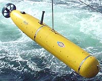
Cambridge MA (SPX) Jan 14, 2005 For Bluefin Robotics' autonomous underwater vehicles (AUVs) and the scientific precision they provide, there's a critical component built into every unit: a Thales DG14 GPS sensor that assures precise navigation at relatively low cost. Bluefin's AUVs are built to the highest standards and cost-effective design for military applications, scientific research, and offshore oil and gas exploration, and aboard every Bluefin AUV is a Thales DG14 GPS sensor to provide the absolute best in GPS navigation at low cost. Bluefin AUVs, designed for shallow water and work down to 4,500 meters, combine the best technology developed by the world-famous MIT AUV Laboratory and the Monterey Bay Aquarium Research Institution to create simple, robust solutions. There are several navigation systems aboard each Bluefin AUV, but only GPS provides the "rock bottom proof" of where you are, said Frank van Mierlo, president of Bluefin. "The high accuracy of the DG14 sensor and its superior multipath mitigation were important reasons why we selected the low-cost, high-performance Thales GPS." The DG14 uses up to 14 GPS L1 Code and carrier channels and incorporates signals from satellite based augmentation systems, including WAAS, EGNOS and MSAS to provide for sub-meter differential positioning. GPS is an important part of the AUV's onboard navigation solution and a critical component in making the inertial navigation system work. The superior multipath mitigation of the DG14 rejects multipath from sea waves and is also very important on the launch deck. Prior to AUV launch from the aft deck of the launch vessel, the inertial navigation system on board the Bluefin AUV must be aligned with data from the GPS sensor on board the AUV. "The alignment is a complex, critical process," said van Mierlo. "Because the aft deck is in the shadow of the vessel's superstructure, cranes and 'A' frames - elements that create multipath, it's a tough environment to receive a good satellite signal. It's a challenge for the GPS sensor to provide the high quality positioning data necessary to align the AUVs inertia navigation system." The digital signal processing techniques of the DG14 provides the best DGPS multipath mitigation available. The DG14 uses the Thales patented Edge and Strobe Correlator technologies to remove multipath errors almost entirely for reflected signal with delay of 37m or more. Bluefin engineers also value the DG14 for its easy configuration and straightforward integration. While the DG14 offers three standard RS232 posts, it is capable of single port operation; one serial port can do it all. It is miserly in its power consumption and can be programmed for low power/sleep mode operation. The DG14 can also be configured to use a Kalman filter with user selectable modes to match operating conditions. Community Email This Article Comment On This Article Related Links Bluefin Robotics Thales Navigation SpaceDaily Search SpaceDaily Subscribe To SpaceDaily Express GPS Applications, Technology and Suppliers
 Cheltenham, England (SPX) Jan 09, 2006
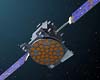
Marotta UK is pleased to announce that it designed, developed and qualified equipment for the cold gas propulsion systems on board the Galileo GIOVE-A, part of Europe's Galileo navigation program, successfully launched by Surrey Satellite Technology (SSTL). |
|
| The content herein, unless otherwise known to be public domain, are Copyright 1995-2006 - SpaceDaily.AFP and UPI Wire Stories are copyright Agence France-Presse and United Press International. ESA PortalReports are copyright European Space Agency. All NASA sourced material is public domain. Additionalcopyrights may apply in whole or part to other bona fide parties. Advertising does not imply endorsement,agreement or approval of any opinions, statements or information provided by SpaceDaily on any Web page published or hosted by SpaceDaily. Privacy Statement |