|
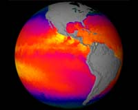
Greenbelt - Feb 14, 2002 A new sensor orbiting the Earth aboard NASA's Terra satellite is now collecting the most detailed measurements ever made of the sea's surface temperature every day all over the globe. Like a sophisticated thermometer in space, the Moderate-resolution Imaging Spectroradiometer (MODIS) is helping Earth scientists advance studies of how our world's oceans and atmosphere interact in ways that drive weather patterns and, over the long term, define our climate. Comparing MODIS' space-based measurements with surface measurements collected from ships and buoys, the MODIS team finds the satellite sensor measures sea surface temperature accurate to within about 0.25 C, which is better than twice the accuracy of previous satellites. Daily global measurements of sea surface temperature (SST) accurate to within half a degree has been a goal of oceanographers for decades. The MODIS team presented their new data product today at the Ocean Sciences 2002 Meeting of the American Society of Limnology and Oceanography and the American Geophysical Union in Honolulu. According to Otis Brown, dean of the Rosenstiel School of Marine and Atmospheric Science and professor of meteorology and physical oceanography at the University of Miami, the need for more accurate measurements of the ocean's temperature is driven by Earth scientists' goal to construct more accurate computer models of our world's climate. Over the last 30 years, scientists have observed perturbations (such as El Nino/La Nina and Pacific Warm Pool Oscillations) that occur within the climate system on different time scales, ranging from years to decades. Yet scientists don't know to what degree changes in the frequency and severity of these phenomena may be due to climate change, or whether they represent the system's natural variability. "When you look at the signatures of various processes in the climate system you really need to drive the error of SST measurements down to 0.1 or 0.2 of a degree so you can monitor changes on yearly and decadal time scales to understand the mechanisms driving the system," Brown explains. "The mechanisms that cause temperature changes have subtle signatures, over time and space, so you need a high degree of accuracy to determine which mechanisms are causing the change." MODIS will be particularly helpful in forecasting events like El Nino and La Nina, says Peter Minnett, professor of meteorology and physical oceanography at the University of Miami. According to Minnett, predicting how those temperature anomalies will affect weather patterns around the world requires accuracy at least as fine as one-tenth the size of the anomaly's signal. In the case of El Nino, part of the equatorial Pacific Ocean is about 2-3 degrees warmer than normal, while during La Nina some parts are 1-2 degrees cooler than normal. Thus MODIS meets scientists' requirement of being accurate to within one-tenth of an El Nino or La Nino signal, thereby permitting earlier detection and more refined study of the events. "MODIS is better equipped than its predecessors to measure SST in the tropics because it can see through the atmosphere better," Brown notes. "This is the first time specially selected spectral bands have been included to provide clear measurements in moist, tropical atmospheres. SST measurements in the tropics are difficult because of the high levels of water vapor in the atmosphere over the region." Like all space-based radiometers, MODIS measures the thermal infrared energy (heat basically) radiated from the sea's surface. Yet, the signal from the ocean is modified by its passage through the atmosphere. The degree to which the signal is modified depends upon the chemistry of the overlying atmosphere. Clouds, haze, dust or smoke can interfere with a space-based remote sensor's ability to accurately measure SST, as can greenhouse gases like water vapor, which is present in abundance in the tropics and strongly absorbs infrared energy and re-radiates it back toward the surface. MODIS is sensitive to five different wavelengths, or "channels," for measuring SST. Both night and day, the sensor measures the thermal infrared energy escaping the atmosphere at 12 microns and then compares that measurement to how much energy is escaping at 11 microns, allowing scientists to determine how much the atmosphere modifies the signal so they can "correct" the data to more accurately derive SST. This same technique has been used for many years by NOAA's Advanced Very High Resolution Radiometer (AVHRR). But, water vapor dominates the atmospheric component of the 11 to 12 micron signal and, therefore, space-based sensors cannot "see" clearly the surface over the tropics, where water vapor is present in abundance. To solve this problem MODIS also has three additional channels between 3.5 and 4 microns for measuring SST at night. MODIS is the first satellite remote sensor to carry these channels. "MODIS has more channels than its predecessors, telling us far more about the behavior of the atmosphere," Minnett states, "so we know better how to compensate for the atmosphere's effects and we can accurately derive the temperature of the sea surface." Launched December 18, 1999, Terra is the flagship of the Earth Observing System series of satellites, part of NASA's Earth Science Enterprise, a long-term research program dedicated to understanding how human-induced and natural changes affect our global environment. Community Email This Article Comment On This Article Related Links Terra Mission at NASA University of Miami SpaceDaily Search SpaceDaily Subscribe To SpaceDaily Express Dirt, rocks and all the stuff we stand on firmly
 Paris (ESA) Jan 12, 2006
Using the ESA Cluster spacecraft and the NASA Wind and ACE satellites, a team of American and European scientists have discovered the largest jets of particles created between the Earth and the Sun by magnetic reconnection. This result makes the cover of this week's issue of Nature. |
|
| The content herein, unless otherwise known to be public domain, are Copyright 1995-2006 - SpaceDaily.AFP and UPI Wire Stories are copyright Agence France-Presse and United Press International. ESA PortalReports are copyright European Space Agency. All NASA sourced material is public domain. Additionalcopyrights may apply in whole or part to other bona fide parties. Advertising does not imply endorsement,agreement or approval of any opinions, statements or information provided by SpaceDaily on any Web page published or hosted by SpaceDaily. Privacy Statement |