|
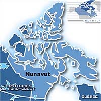
Boulder CO (SPX) Feb 15, 2006 Twin sets of topographic data compiled by ESA satellites are providing newly detailed maps of the Canadian landscape, including Nunavut, its newest and largest territory. Nunavut, whose population is less than 30,000, has a land area the size of Western Europe. The Canadian government currently is updating its geographic information for the entire country, but for Nunavut in particular, in hopes of assessing development potential. Vexcel Canada, the prime contractor in the effort, has completed 21 digital elevation model (DEM) map sheets for the Centre for Topographic Information Sherbrooke, the agency supervising the countrywide mapping. DEMs are representations of variations in the Earth's surface altitude in digital format that can be used for a variety of applications, including mineral exploration, planning mobile phone networks and selecting routes for pipelines or roads. To be most useful, DEMs must provide high resolution and extreme accuracy across wide areas. Vexcel Canada is creating the maps by combining two or more synthetic aperture radar images of the same site acquired from close to the same orbital position. The aim is to obtain extremely precise topographical information. The company is using a customized version of its own software, called EarthView InSAR, which can spot the slightest change in the distance the bouncing radar signals travel. The changes cause shifts in signal phase and set up interference patterns, which InSAR uses to created multi-colored images are called interferograms. The Canadian Space Agency helped with the customization. Because satellite orbits vary slightly, the two European Remote Sensing satellites did not produce radar images from precisely the same point in space, but InSAR can exploit those differences to derive elevations across wide areas and produce effects similar to 3-D images. The ERS data - consisting of 140,000 image pairs - are now nearly a decade old, but they remain useful today because the brief 24-hour satellite revisit time produced great coherence. ERS tandem coverage also extends above 60� north and south, further than comparable datasets such as NASA�s Shuttle Radar Topography Mission, and the ERS tandem dataset continues to be used widely, for mapping forests and measuring glacial motion, among other applications. "The (map sheets) produced by Vexcel are the best 1:50 000 scale DEMS produced using synthetic aperture radar satellite technology that we have ever seen," said Yves Robitaille, Project Manager for CTIS. "Certainly Vexcel met and exceeded our expectations." The company has produced complete elevation data for 44 map sheets across Nunavut, meeting specifications for Canadian Digital Elevation Data (CDED) of better than 7.5 meters vertical accuracy at around 20 meter postings. In a statement, ESA said the ERS tandem mission has paved the way for a new generation of SAR surveys. For example, Canada is incorporating the tandem concept into its Radarsat-2/-3 mission, and Germany is doing the same for its TanDEM-X. Those satellites will fly with time separations measured in minutes, rather than the one day between ERS-1 and ERS-2. This should improve interferogram quality, because of the smaller changes occurring on the ground between acquisitions, the space agency said. Community Email This Article Comment On This Article Related Links ESA Earth Observation News - Suppiliers, Technology and Application
 Paris, France (SPX) Feb 20, 2006
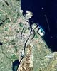
This Proba image shows the historic port of Copenhagen, the capital of Denmark for the last 600 years. Appearing off the coast like a string of pearls is a 21st Century addition to the city: one of the largest offshore wind farms in the world. |
|
| The content herein, unless otherwise known to be public domain, are Copyright 1995-2006 - SpaceDaily.AFP and UPI Wire Stories are copyright Agence France-Presse and United Press International. ESA PortalReports are copyright European Space Agency. All NASA sourced material is public domain. Additionalcopyrights may apply in whole or part to other bona fide parties. Advertising does not imply endorsement,agreement or approval of any opinions, statements or information provided by SpaceDaily on any Web page published or hosted by SpaceDaily. Privacy Statement |