|
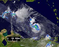
Greenbelt MD (SPX) Aug 18, 2004 Since rain and freshwater flooding are the number one causes of death from hurricanes in the United States over the last 30 years, better understanding of these storms is vital for insuring public safety. A recent study funded by NASA and the National Science Foundation offers insight into patterns of rainfall from tropical storms and hurricanes around the world. Researchers at the University of Miami's Rosenstiel School of Marine and Atmospheric Science, Miami, and the National Oceanic and Atmospheric Administration Atlantic Oceanographic and Meteorological Laboratory's Hurricane Research Division, Miami, used data from NASA's Tropical Rainfall Measuring Mission (TRMM) satellite to show how rain falls at different rates in different areas of a storm. The results were published in the July issue of the journal Monthly Weather Review. The results are already being used in a model developed at the Hurricane Research Division to estimate rainfall accumulation related to tropical cyclones. The findings are important because they may help in the development of better forecasts. The TRMM satellite offers the best measurements of how and where rain falls around tropical cyclones. This is because its orbit is low to the Earth, allowing more detailed information on storms, and it was designed to cover the tropics. Tropical cyclones consist of winds rotating around low-pressure centers in the tropics that can develop into everything from tropical storms to Category 5 hurricanes. From 1998 through 2000, TRMM observed 260 tropical cyclones in six major ocean basins. Researchers found that the rainfall intensity and where the heaviest rains fell varied depending on a storm's wind speeds, its location and the environment of each basin. Scientists looked at three types of tropical cyclones, based on a standard system for classifying these storms. Tropical storms have wind speeds of less than 73 miles per hour (mph). Category 1 and 2 hurricanes blow with winds of 74 to 110 mph, and Category 3 to 5 hurricanes' winds range above 110 mph. "This study is important because we know very little about the rainfall distribution in tropical cyclones," said lead author of the study, Manuel Lonfat, a University of Miami researcher. "It revolutionizes our understanding of the distribution of rain in tropical cyclones," he added. Lonfat is a NASA Earth System Science Fellowship recipient. "More than 50 percent of deaths in the U.S. from tropical cyclones over the last 30 years are related to freshwater flooding. So this is currently a very large problem for the forecasting community," Lonfat said. When all storms were averaged together the most intense rainfall occurred within 50 kilometers (about 31 miles) of a storm's center, with evidence of very large rain rates as far as 300 to 400 kilometers (about 186 to 250 miles) from the center. When all storms were averaged and analyzed basin by basin, storms in the North Indian basin were the wettest, and East-central Pacific storms were the driest. The Atlantic and West Pacific storms showed similar rain rates: this at first surprised the researchers since Western Pacific storms tend to be bigger and were presumed to be wetter. Researchers also found that the storms were not symmetric, meaning that rain fell at different rates in different areas of a storm. If a round storm were divided into four equal parts through the center, called quadrants, in general it was found that the heaviest rainfall occurred in one of the front quadrants. However, the heaviest rainfall shifted from the front-left to the front-right quadrant as a tropical cyclone's intensity increased. Tropical storms were less symmetric, while stronger hurricanes had a more symmetric inner core. In the Southern Hemisphere, the heaviest rain occurred to the front-left of the storm's path, while in the Northern Hemisphere the heaviest rainfall peaked in the front-right quadrant. Normally, the only way to accurately measure rain falling from a hurricane is when it gets close enough to the coast to be picked up by National Weather Service radars, or by rain gages. Since TRMM is space-based, researchers can assess the rainfall over vast tracts of ocean, where these storms spend most of their lives. Community Email This Article Comment On This Article Related Links TRMM at NASA SpaceDaily Search SpaceDaily Subscribe To SpaceDaily Express Earth Observation News - Suppiliers, Technology and Application
 New York NY (SPX) Jan 11, 2006
The importance of remotely sensed data and technologies to support natural disasters has prompted attention and action in Washington. New initiatives and legislation authorizing appropriations to the remote sensing industry will be discussed at Strategic Research Institute's U.S. Commercial Remote Sensing Industry conference, scheduled for February 9-10, 2006 in Washington D.C. |
|
| The content herein, unless otherwise known to be public domain, are Copyright 1995-2006 - SpaceDaily.AFP and UPI Wire Stories are copyright Agence France-Presse and United Press International. ESA PortalReports are copyright European Space Agency. All NASA sourced material is public domain. Additionalcopyrights may apply in whole or part to other bona fide parties. Advertising does not imply endorsement,agreement or approval of any opinions, statements or information provided by SpaceDaily on any Web page published or hosted by SpaceDaily. Privacy Statement |