|
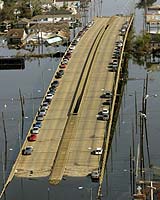
Paris (AFP) May 31, 2006 Areas of New Orleans had been sinking for years before Hurricane Katrina flooded the city, and the worst subsidence occurred at levees that were easily breached by the storm's surge, a study says. "Parts of New Orleans underwent rapid subsidence in the three years before Hurricane Katrina struck in August 2005," says the paper, published in the British science journal Nature and authored by a University of Miami team. The evidence comes from radar images taken from 2002 to 2005 by a Canadian satellite, RADARSAT. Carefully overlaid, the 33 images show that, overall, the city sank by an average of 5.6 millimetres (0.22 inches) a year during this time. As global sea levels, driven by the greenhouse effect, are rising by around 2mm (0.07 inches) a year, this means the city was subsiding relative to the sea at around 8mm (0.3 inches) annually. But the study says the subsidence is likely to have carried on over a much longer term -- and some parts of the city had been sinking much faster than others. It cited the districts of Lakeview, on the south shore of Lake Pontchartrain; Kenner, near Louis Armstrong New Orleans International Airport in east New Orleans; and regions bordering St. Bernard Parish, west of Lake Borgne. In this latter area, subsidence ran at at more than 20mm (0.8 inches) a year from 2002 to 2005, especially at the levee system along the Mississippi River-Gulf Outlet (MRGO), a canal where some of the worst breaches in flood protection occurred. Stealthy subsidence over many years would mean that the levees could be easily topped by the storm surge without engineers being aware of the problem. Scientists discovered after Katrina that water levels exceeded those expected for the storm by between 90cm (35 inches) and 1.7m (66 inches). Another possibility, though, is that the subsidence promoted failure at the base of the levees, enabling the walls to be smashed aside by the surge. As for the cause of the subsidence, the paper points the finger at the drainage of wetlands, causing highly organic soil to get dried out and compacted, although in eastern New Orleans, an active fault may have increased the problem. Lead author is Timothy Dixon, of the University of Miami's Rosenstiel School of Marine and Atmospheric Science. Community Email This Article Comment On This Article Related Links Bringing Order To A World Of Disasters A world of storm and tempest When the Earth Quakes
 Washington (AFP) May 31, 2006
 Animal welfare advocates on Wednesday said they had worked with the US government to develop new measures to protect pets in the event of another natural disaster like Hurricane Katrina, in which tens of thousands of pets died. |
|
| The content herein, unless otherwise known to be public domain, are Copyright 1995-2006 - SpaceDaily.AFP and UPI Wire Stories are copyright Agence France-Presse and United Press International. ESA PortalReports are copyright European Space Agency. All NASA sourced material is public domain. Additionalcopyrights may apply in whole or part to other bona fide parties. Advertising does not imply endorsement,agreement or approval of any opinions, statements or information provided by SpaceDaily on any Web page published or hosted by SpaceDaily. Privacy Statement |