|
Wichita - Nov 19, 2003 Each year, hundreds of motorists are killed or injured while driving on Interstate highways during severe weather conditions, hikers and outdoor enthusiasts are threatened by the dangers of unexpected lightning and businesses lose millions due to storm damage to mission critical equipment. In an effort to bring safety and security to American consumers and companies, a new product is now available. WeatherData, Inc., North America's leading provider of weather risk management services and weather forecasting products, announced today the launch of Storm Hawk, the world's first mobile, hand-held weather and navigation system. Designed to improve safety for recreational users including boaters, drivers and outdoor enthusiasts, as well as businesses and industries with weather sensitive operations, Storm Hawk features weather-overlaid mapping based on Global Positioning Satellite (GPS) data which is displayed on a personal digital assistant (PDA). "We live in a mobile world," said Mike Smith, Founder and CEO of WeatherData, Inc. "With Storm Hawk, people on the go now have instant access to detailed weather reports and the weather hazards affecting them directly. We no longer need to be caught by unexpected storms, like the recent flash flood in Kansas that killed six Interstate motorists. If dangerous conditions approach, Storm Hawk allows users to respond accordingly." Using cellular or satellite communications, Storm Hawk presents customizable critical weather information of interest to the user, centered on the user. Real-time radar and lightning data provide exact storm locations, while reporting features include land and sea surface observations such as temperature, visibility, wind direction, wind speed and National Weather Service storm warnings. By using precision mapping that includes street names, Storm Hawk offers real-time information while users are in motion. Maps rotate accordingly so the top of the display corresponds to the direction of travel. "One of Storm Hawk's greatest benefits is that it gives users additional time to plan and react to potentially life threatening situations," said Smith. Special features will be available for marine use including marine charts for the U.S. and surrounding coastal waters, and reports on wave height, buoy observations, high surf advisories and tide data tables. A future version of Storm Hawk will also offer predicted radar that includes the location of storms ten to 30 minutes into the future and will provide the location and prediction of cloud-to-ground lightning with up to 97 percent accuracy, a WeatherData exclusive service. Using a HP/Compaq iPAQ, Storm Hawk incorporates a powerful zoom capability of one mile to 250 miles, has a radar download time of less than one minute and weighs under two pounds fully equipped. For mission-critical business operations, Storm Hawk displays WeatherData's precision SkyGuard warnings tailored to the requirements of each individual client. SkyGuard is WeatherData's proprietary storm intelligence and risk management service. Storm warnings are tailored to the client's specific requirements to minimize downtime while maximizing safety. To provide maximum security to corporate users, Storm Hawk interfaces with WeatherData's GIS command center, SelectWarn. SelectWarn displays the location of each Storm Hawk so an entire fleet, including each member of the fleet's relation to hazardous weather, can be tracked from a home location, whether carried by a person or a vehicle. In addition, SelectWarn's unique addressing capability allows messages to be transmitted to all, individual or a select group of Storm Hawks. The SelectWarn and Storm Hawk combination facilitates the most advanced weather risk management service possible for supply chain, field and critical site operations. A full wireless Storm Hawk package includes Storm Hawk software, HP/Compaq iPAQ PDA, HP dual-slot expansion pack, PC card GPS, and a Sprint AirCard for $1,595. The satellite phone package includes Storm Hawk software, HP/Compaq iPAQ PDA, HP dual-slot expansion pack, PC card GPS, Globalstar satellite phone, satellite phone data adapter cable, and PDA adapter/data cable for $1850. Users also need to subscribe to monthly cellular or satellite phone service as well as a $9.95 monthly Storm Hawk weather subscription. Community Email This Article Comment On This Article Related Links WeatherData SpaceDaily Search SpaceDaily Subscribe To SpaceDaily Express GPS Applications, Technology and Suppliers
 Cheltenham, England (SPX) Jan 09, 2006
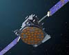
Marotta UK is pleased to announce that it designed, developed and qualified equipment for the cold gas propulsion systems on board the Galileo GIOVE-A, part of Europe's Galileo navigation program, successfully launched by Surrey Satellite Technology (SSTL). |
|
| The content herein, unless otherwise known to be public domain, are Copyright 1995-2006 - SpaceDaily.AFP and UPI Wire Stories are copyright Agence France-Presse and United Press International. ESA PortalReports are copyright European Space Agency. All NASA sourced material is public domain. Additionalcopyrights may apply in whole or part to other bona fide parties. Advertising does not imply endorsement,agreement or approval of any opinions, statements or information provided by SpaceDaily on any Web page published or hosted by SpaceDaily. Privacy Statement |