|
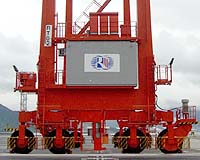
Fredericton - Aug 22, 2002 The seaports of the world present a huge challenge to those who work there. Shipping containers, 20-to-40 feet in length, have to be stacked within inches of each other, and the slightest mistake could result in thousands of dollars in damage. Two researchers at the University of New Brunswick in Fredericton have developed guidance software to simplify this enormous task. Donghyun Kim and Richard Langley of the department of geodesy and geomatics engineering, contracted by Seoho Electric Company Ltd. of Korea, have created a guidance system to steer giant port cranes using the Global Positioning System (GPS). Standard mechanisms currently used to guide port cranes use cameras mounted on the sides of the cranes. The cameras rely on lines painted on the ground to keep the crane from running into stationary containers. "The problem with painted lines is that they have to be perfectly maintained," explains Dr. Kim, who has been a research scientist at UNB since 1998. "Worn paint, rain, ice, snow � any of these things can hamper the ability of the guidance system. "The nice thing about this new software is that it does not rely on actual painted lines. It digitally maps the port and uses GPS to control the crane's actions." The new system uses a GPS base station located at the port and a pair of GPS receivers on the crane. The software can then determine the crane's location using the base and crane receivers and the GPS satellites. Its accuracy is within a few centimetres. "It's not the only GPS-based guidance system, but it might be the best one," says Dr. Langley, who has been a professor at UNB since 1981. The new technology was almost exclusively developed by Dr. Kim, but he did receive help from Dr. Langley and some of his department's graduate students. The software was written and tested over the past year with field-testing completed this spring. The field-testing site was one of the container ports located in Kwangyang, Korea. Dr. Kim traveled there with graduate student Sunil Bisnath and conducted tests in May. While testing was scheduled to take two weeks, the researchers encountered problems and ended up taking more than a month. "Everything went well in the lab, but it is easier there than in the real world. It's not until you get out in the field that you find all the problems," explains Dr. Langley. Even though the field-testing seemed like a daunting task, Dr. Kim never strayed from the project. "I stayed at the test site until 12 every night and returned at five or six in the morning. I may have been physically tired, but I was always cheerful. The guidance system was constantly challenging me to get it right," says Dr. Kim. Seoho is now marketing the new guidance system and UNB welcomes interest in new applications for the technology. Drs. Kim and Langley are already researching the next generation of GPS-based guidance systems. Future systems could include the ability to send GPS data through the Internet, which would allow GPS base stations and remote receivers to operate at any distance. As Dr. Langley points out, "Technology marches ahead and we want to be in the lead." Community Email This Article Comment On This Article Related Links Dept. of Geodesy and Geomatics Engineering SpaceDaily Search SpaceDaily Subscribe To SpaceDaily Express GPS Applications, Technology and Suppliers
 San Jose CA (SPX) Jan 04, 2006
Continuing to drive GPS further into the mainstream market, SiRF Technology Holdings has revealed that its flagship SiRFstarIII GPS technology is at the heart of TomTom's RIDER, a high performance portable navigation system specifically designed for use on motorcycles and scooters. TomTom is a leading provider of personal navigation products and services to the US and European consumer markets. |
|
| The content herein, unless otherwise known to be public domain, are Copyright 1995-2006 - SpaceDaily.AFP and UPI Wire Stories are copyright Agence France-Presse and United Press International. ESA PortalReports are copyright European Space Agency. All NASA sourced material is public domain. Additionalcopyrights may apply in whole or part to other bona fide parties. Advertising does not imply endorsement,agreement or approval of any opinions, statements or information provided by SpaceDaily on any Web page published or hosted by SpaceDaily. Privacy Statement |