|
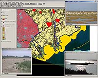
Kampala, Uganda (ESA) Nov 14, 2005 Last week ESA joined around a thousand participants from 146 countries at the main policy making forum of the Ramsar Convention on Wetlands in Kampala, Uganda. Friday saw the presentation of results from an Agency-led initiative to develop a global wetland information service using satellites. National delegates along with representatives from international organisations and non-governmental organisations (NGOs) have met in Uganda's capital for the eight-day Ninth Meeting of the Conference of the Contracting Parties (COP 9) to the Ramsar Convention on Wetlands, which began on 8 November. The theme of this COP is 'Wetlands and water: supporting life, sustaining livelihoods'. The abundant waters of the wetlands scattered across our planet make them zones of rich biological diversity. Provided wetlands remain intact, they provide a range of additional services and benefits to local communities including flood and erosion prevention, water storage and purification, nutrient recycling and the provision of food and animal fodder, improving the livelihoods of millions of people and making a major contribution to sustainable development. For much of the 20th Century wetlands were drained or otherwise degraded. However increased understanding of the vital importance of wetlands led to the signing of Ramsar in 1971. Among the activities of the current Ramsar COP is deciding new additions to the 1524 wetlands so far designated as Wetlands of International Importance � making up a total of 129 million hectares listed worldwide, with national signatories pledged to preserve the ecological character of sites on their territory and report on their status. Being presented Friday to delegates at a COP 9 side event were initial results from an ESA-initiated service that uses Earth Observation technology to make that task easier. The Globwetland project employs satellite imagery to provide detailed wide-area views of individual wetlands and their surrounding water catchments, and show changes over time. The intention is for Globwetland products to serve as tools of local wetland managers as well as a means to aid Ramsar reporting. Accordingly Globwetland is user-oriented, with the information products now being prototyped being based on the specific requests of local and national users from 50 wetland sites in 21 countries across four continents: Africa, North and South America, Europe (including European Russia) and Africa. Wetland manager users are also helping to ground-truth the Globwetland products. Guided by user requirements, Globwetland core products include base maps, land-use-land-cover (LULC) maps and change detection maps, with historical satellite images being compared with current acquisitions to highlight shifts that have occurred during the past decade or more. Water cycle regime monitoring maps are also being created, using Envisat and Radarsat radar data to show flood and retreat patterns. Specialised products available by request include digital elevation models (DEMs) and biophysical data acquired from multispectral satellite sensors, showing vegetation health based on chlorophyll levels, or the sediment content of wetland water bodies. ESA is also manning a stand with information on Globwetland throughout the eight-day COP 9. The overall need for Globwetland products is clear: COP 9 began with the release of the Wetlands Synthesis Report of the Millennium Ecosystem Assessment (MEA), which is an international programme on ecosystem change launched by United Nations Secretary General Kofi Annan in June 2001 and completed in March 2005. The results show that wetlands are the hardest-hit of all ecosystems, and that their decline has accelerated in recent years. Vexcel Canada Inc is leading the Globwetland consortium on behalf of ESA's Data User Element (DUE), with subcontractors Remote Sensing Solutions GmbH of Germany and GIS Applications of the Netherlands. The Netherlands-based Wetlands International is also taking part, both as a sub-contractor and also as a link to the global wetland science community. Community Email This Article Comment On This Article Related Links Globwetland Ramsar Convention Vexcel SpaceDaily Search SpaceDaily Subscribe To SpaceDaily Express Earth Observation News - Suppiliers, Technology and Application
 New York NY (SPX) Jan 11, 2006
The importance of remotely sensed data and technologies to support natural disasters has prompted attention and action in Washington. New initiatives and legislation authorizing appropriations to the remote sensing industry will be discussed at Strategic Research Institute's U.S. Commercial Remote Sensing Industry conference, scheduled for February 9-10, 2006 in Washington D.C. |
|
| The content herein, unless otherwise known to be public domain, are Copyright 1995-2006 - SpaceDaily.AFP and UPI Wire Stories are copyright Agence France-Presse and United Press International. ESA PortalReports are copyright European Space Agency. All NASA sourced material is public domain. Additionalcopyrights may apply in whole or part to other bona fide parties. Advertising does not imply endorsement,agreement or approval of any opinions, statements or information provided by SpaceDaily on any Web page published or hosted by SpaceDaily. Privacy Statement |