|
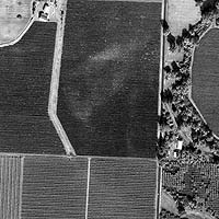
Denver - February 15, 2000 - Space Imaging announced today the availability of high-resolution satellite imagery for the agricultural industry. This high-quality satellite-based information has never before been available to the commercial marketplace and will revolutionize the way the agricultural community does business and makes decisions. "This imagery, combined with other data, provides the world's most detailed and comprehensive suite of visual information products to meet the needs of farmers, consultants, planners and analysts," stated Brian Soliday, vice president of Space Imaging North American sales and marketing. Space Imaging's high-resolution satellite images, marketed under the company's CARTERRA brand name, are state-of-the-art products for the agricultural community. The one-meter resolution panchromatic (black-and-white) images, collected by the IKONOS satellite, have clarity that is the first of its kind in the commercial market. The four-meter resolution multispectral (color) digital images can be displayed to include the near- infrared band to allow quantitative analysis of crop vigor. This information is not visible to the naked eye. IKONOS images show detailed features such as trees, buildings and trucks, and can even help pinpoint precise problem growing areas in a field. Agri-business customers can use the digital images for:
According to Dr. Chris Johannsen, Professor of Agronomy and Director of the Laboratory for Applications of Remote Sensing, at Purdue University in Indiana: "Advances in remote sensing technology are changing the way we look at agriculture." "Precision farming has caused farmers to want more information about every part of their field so they can make more effective decisions about their crops. IKONOS is clearly paving the way toward making agricultural monitoring a reality so that farmers are able to reach their management and planning goals," added Johannsen. While John Rasure, President of EarthScan Network adds: "Imagery from IKONOS, combined with new digital technologies for delivering images to the agriculture community quickly and affordably, is enabling us to transform what has traditionally been a very complicated and expensive process into a product that provides management solutions for the farmer. Together, these technologies are already having an impact on the way the agricultural community does business."
Email This Article Comment On This Article Related Links Space
 Calcutta, India (SPX) Dec 28, 2005
The successful launch Thursday of India's heaviest satellite from spaceport of Kourou in French Guyana may have boosted the country's space research efforts to yet another level, but it has also lifted the spirits of at least three Direct-To-Home televisions broadcasters, one of which has been waiting for years to launch its services in India. |
|
|
|
|
|
|
|
|
|
|
|
|
|
| The content herein, unless otherwise known to be public domain, are Copyright 1995-2006 - SpaceDaily.AFP and UPI Wire Stories are copyright Agence France-Presse and United Press International. ESA PortalReports are copyright European Space Agency. All NASA sourced material is public domain. Additionalcopyrights may apply in whole or part to other bona fide parties. Advertising does not imply endorsement,agreement or approval of any opinions, statements or information provided by SpaceDaily on any Web page published or hosted by SpaceDaily. Privacy Statement |