|
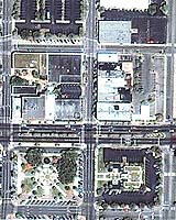
Denver - Apr 14, 2004 Space Imaging has completed a comprehensive asset management system (AMS) for the Marion County, Florida Engineering department valued at $2.8 million. Space Imaging's Solutions group developed the AMS for the county as a tool to manage a rapidly developing infrastructure to support rising population influxes and to help Marion County comply with the federal Governmental Accounting Standards Board Statement 34 (GASB 34) requirements. With more than 2,300 paved and 500 unpaved road miles, Marion County has undergone increasing growth and development in recent years, further stimulating the need for a comprehensive up-to-date assessment for county authorities. Most importantly, the county needed to obtain a more accurate accounting of all infrastructure assets to be in compliance with GASB 34. The new AMS eliminates superfluous records, fosters intra-departmental communications and assists with GASB 34 reporting and compliance. According to Bob Titterington, Marion County's original manager on the project, Space Imaging's one-stop shop of high-resolution imagery combined with a full GIS production capability was a key purchasing decision point. "We liked that we could get the whole project done with one vendor," Titterington said. Newly collected 1-meter resolution IKONOS satellite imagery allowed the joint Space Imaging-Marion County team to develop a cost-effective methodology to locate, map, inventory, assess condition levels, and determine the value of the county's road and storm water assets. In addition, the IKONOS imagery was used as the basis for new countywide maps of storm sewer facilities to satisfy National Pollutant Discharge Elimination System (NPDES) requirements. Satellite imagery, coupled with higher-resolution aerial photographs, also allowed the team to determine pavement edges in order to obtain exact roadway measurements. The asset management solution utilized both field data collection and image-based feature extraction to build the required asset databases. Space Imaging and Jones, Edmunds and Associates, Inc. have been working with the county's Engineering department to collect roadway asset data for incorporation into the integrated AMS. More than 40,000 data points with full attribution were collected and entered into the AMS in less than six months. The map-accurate IKONOS imagery also allowed the team to determine roadway characteristics in order to obtain accurate roadway measurements. This information was vital to developing a Pavement Management System that is currently in use by the county. The Engineering department now has the ability to monitor the overall health of its road network through proactive management techniques developed by the Space Imaging team. Engineers are also using this system to plan for future maintenance activities as well as for tracking financial information related to current construction activities. "Marion County is leading the way in terms of proactive, enterprise-wide, asset management. Not only are they tracking all of their infrastructure assets in their AMS, but also they are proactively developing better techniques and business processes that allow for accurate and efficient daily workflow. In other words, they're increasing their level of service to their residents," said Jason Amadori, Space Imaging's manager of Southeast Operations. From a technical standpoint, the objective was to make the AMS a complete GIS product, easy to use and simple to update. Space Imaging's Solutions group devised both components to be compatible for fieldwork on PDAs. ESRI's ArcPad software was used to make the necessary mobile maps with full GIS capabilities for field use. Space Imaging also administered user training to Marion County officials and will continue to deploy on-site support. To learn more about the Marion County project and Space Imaging's asset management system visit Community Email This Article Comment On This Article Related Links Marion County Aset Management Project at SpaceImaging SpaceDaily Search SpaceDaily Subscribe To SpaceDaily Express Earth Observation News - Suppiliers, Technology and Application
 New York NY (SPX) Jan 11, 2006
The importance of remotely sensed data and technologies to support natural disasters has prompted attention and action in Washington. New initiatives and legislation authorizing appropriations to the remote sensing industry will be discussed at Strategic Research Institute's U.S. Commercial Remote Sensing Industry conference, scheduled for February 9-10, 2006 in Washington D.C. |
|
| The content herein, unless otherwise known to be public domain, are Copyright 1995-2006 - SpaceDaily.AFP and UPI Wire Stories are copyright Agence France-Presse and United Press International. ESA PortalReports are copyright European Space Agency. All NASA sourced material is public domain. Additionalcopyrights may apply in whole or part to other bona fide parties. Advertising does not imply endorsement,agreement or approval of any opinions, statements or information provided by SpaceDaily on any Web page published or hosted by SpaceDaily. Privacy Statement |