|
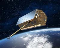
Bonn, Germany (SPX) Sep 21, 2006 This year, for the first time, a new German satellite, TerraSAR-X, will be launched in a project financed by joint funding from both the public and private sectors. As contractor, the German Space Agency, part of of the German Aerospace Agency (DLR), is responsible for management of the entire project and, together with DLR research institutes, will pay 80 percent of the satellite's cost; EADS SPACE built the satellite and is financing the remaining 20 percent. In addition, DLR's research institutes are building the ground segment used to control the satellite as well as the operational and calibration systems for the radar equipment and data receivers. They will also oversee the mission over a five-year period and process, archive and distribute received data to the science community. Using the Public-Private Partnership (PPP) model, Germany has taken a pioneering step and established itself as a global leader in space exploration. The long-term aim of the TerraSAR-X mission is to provide both scientific and industrial users with remote-sensing data collected using radar. Use of the data by the science community will be coordinated by DLR's German Remote Sensing Data Center (DFD), while Infoterra GmbH, a subsidiary of EADS SPACE, will develop geoinformation products and will market the data commercially. In this way both commercial and scientific users will share access to the available observation time. The overall cost for the construction and launch of the satellite amounts to about �130 million, of which the space agency at DLR has contributed �102 million and EADS SPACE, �28 million. An extra �55 million will be needed to develop the ground segment and fund operation of the satellite over five years; of this, �45 million will come from research institutes at DLR and the remaining �10 million will be invested by Infoterra GmbH. Germany - leader in Earth observation TerraSAR-X is vital in achieving the goals set by the German space exploration programme and for German end users in both research and industry. The radar technology being employed, along with the optics and LIDAR (Laser detection and radar) technology, is a technological core strength of both DLR and Germany's space exploration industry. Germany has thus gained an international leading role in Earth observation. Numerous European satellites have been built under the leadership of German companies, including ERS, SRTM, ENVISAT, Cryosat and SWARM. With the competence of DLR's research institutes in processing and storage, Germany has achieved a major role in the scientific evaluation and use of Earth observation data. TerraSAR-X is the culmination of a long and successful scientific and technological development effort in Germany, which began at the end of the 1970s with the keen support of DLR's Space Agency. In April and September 1994, two X-SAR (X-Band Synthetic Aperture Radar) experiments flew on the Space Shuttle, each mission lasting about 10 days. They operated in conjunction with NASA's SIR-C (Spaceborne Imaging Radar - C-Band) radar system. With the success of the two X-SAR missions, the radar instrument was further developed into an interferometer and in February 2000, the technology was again used in conjunction with NASA on the SRTM (Shuttle Radar Topography Mission). Numerous German missions in development - strong participation by DLR As well as participating in the TerraSAR-X mission, DLR is also taking part in RapidEye, the world's first commercial fleet of satellites. Further, the planned TanDEM-X mission will initially orbit in tight formation with TerraSAR-X, with the aim of delivering a global Digital Elevation Model having unprecedented accuracy. As well as the above-mentioned projects, DLR is overseeing advanced developments in the area of future operational meteorological systems, e.g. METimage. In view of Germany's role as the largest contributor to Europe's Earth observation programmes, DLR is clearly the driving force of European Earth observation. The resulting scientific and technological developments can also be harnessed for commercial use in partnership with industry. Community Email This Article Comment On This Article Related Links German Aerospace Center Making money out of watching earth from space today Earth Observation News - Suppiliers, Technology and Application
 Madison WI (SPX) Sep 21, 2006
Mark Harrower recalls a raging debate in his field in the 1970s, when some geographers worried that commercial map-making software would trigger the demise of cartography. The argument went like this: "We are screwed, because now anyone without any technical knowledge or artistic skill can make a map." |
|
| The content herein, unless otherwise known to be public domain, are Copyright 1995-2006 - SpaceDaily.AFP and UPI Wire Stories are copyright Agence France-Presse and United Press International. ESA PortalReports are copyright European Space Agency. All NASA sourced material is public domain. Additionalcopyrights may apply in whole or part to other bona fide parties. Advertising does not imply endorsement,agreement or approval of any opinions, statements or information provided by SpaceDaily on any Web page published or hosted by SpaceDaily. Privacy Statement |