|
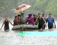
Cookeville TN (SPX) Sep 13, 2005 The effects of Hurricane Katrina, the flood devastation in Mumbai, India, earlier this summer and other water-related disasters potentially could be lessened if a proposed satellite infrastructure becomes reality, according to Faisal Hossain, a Tennessee Tech University civil and environmental engineering professor. "Although the United States has extensive ground radar, 'data denial' occurs when catastrophic weather, such as Hurricane Katrina, strikes," said Hossain, "Those extensive networks are rendered non-functional or destroyed during harsh weather. This is just one of the dire situations where predicting subsequent rainfall and water movement could save lives." Currently a multinational collaboration, including NASA, other space agencies and universities, is working on global precipitation measurement that would speed up the availability of information about rainfall. A constellation of satellites could send information when ground systems are inadequate or to areas where they are non-existent. A computer model based on space-borne monitoring of rainfall before and after Hurricane Katrina could then have given people more time to prepare or increased their impetus to respond, said Hossain. Also, information about moving water could have been sent outside the affected area when land-based communication systems failed. But Katrina's victims are not the only ones who could have benefited from space-borne rainfall information recently. More than 1,000 people died in Mumbai (the city formerly known as Bombay) in July when floodwaters covered the area. Unlike the United States, many areas such as South and Southeast Asia, Central and Southern Africa and nations in the Amazon river basin, have little or no ground infrastructure for rainfall measurement. There are other reasons to rely more on space-borne satellite systems. Although ground radar currently is more accurate than satellite readings, about three-fourths of the earth's surface is covered by the ocean, so only satellites can measure rainfall practically over 75 percent of the earth's surface. Also, insufficient communication technology or lack of proper political environment can prevent nations from sharing rainfall information measured by ground networks. GPM would reduce the need for cooperation, and allow each area or nation to receive information in almost real-time, within about three to six hours. In his native Bangladesh, farmers receive flood forecasts with a maximum of three days lead time due to lack of rainfall data from upstream nations, whereas the hydrological reality indicates that a 14-21 day forecast may be possible. However, Hossain said if farmers had 7-14 days advance notice of inclement flooding, they could adjust planting or harvesting schedules to avoid losses. GPM could increase the accuracy of such long-term forecasts and play a positive role in the food security of developing nations. "This multinational effort is important," said Hossain, who has been working on GPM for five years. "Ideally it would be as if all the cellular networks combined their efforts to give 100 percent coverage. Working with agencies in Europe, Japan, India and Brazil, GPM hopes to create almost 100 percent coverage and access so that flood-prone areas can better prepare themselves for the catastrophic effects of rainfall." Hossain speculated that federal budget freezes could delay the progress of GPM, but he expects to see a functional system in place in five to seven years. Meanwhile, he and researchers will continue to find ways to improve and enhance space-borne data more in line with that of current ground radar systems. Community Email This Article Comment On This Article Related Links Tennessee Tech University SpaceDaily Search SpaceDaily Subscribe To SpaceDaily Express Bringing Order To A World Of Disasters A world of storm and tempest When the Earth Quakes
 Bangalore, India (SPX) Jan 11, 2006
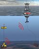
Indian Space Research Organisation is developing ocean bottom sensors that will help warn tsunami strikes in advance, the Press Trust Of India reports. |
|
| The content herein, unless otherwise known to be public domain, are Copyright 1995-2006 - SpaceDaily.AFP and UPI Wire Stories are copyright Agence France-Presse and United Press International. ESA PortalReports are copyright European Space Agency. All NASA sourced material is public domain. Additionalcopyrights may apply in whole or part to other bona fide parties. Advertising does not imply endorsement,agreement or approval of any opinions, statements or information provided by SpaceDaily on any Web page published or hosted by SpaceDaily. Privacy Statement |