|
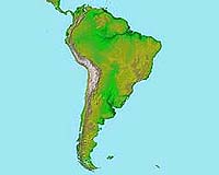
Pasadena - Jun 22, 2003 Straddling the equator and engaged in a titanic clash of great tectonic plates, South America is home to some of the world's most scenic landscapes. Yet this same proximity to the equator, with its frequent tropical cloud cover, has made it difficult to obtain traditional satellite imagery of this vast land. Thanks to cloud-penetrating radar flown on NASA's Shuttle Radar Topography Mission, Feb. 11 through 22, 2000, more than 340 million residents of the fourth largest continent have access to the same level of high-resolution topographic data North America and much of Europe have taken for granted. A just released topographic data set sheds light on the diverse characteristics of South America and paves the way for a wide variety of scientific investigations and commercial applications. "These data, and previously released data, continue to demonstrate the extraordinary value space-based radar can provide for better understanding and protecting our home planet," said Dr. Ghassem Asrar, associate administrator for Earth sciences, NASA Headquarters, Washington, D.C. "This information has scientific and commercial value that will help to improve life here, and provides new understanding of how South America has evolved through time." "These new data highlight the tremendous diversity of South America's geology as never before," said Dr. Michael Kobrick, Shuttle Radar Topography Mission project scientist at NASA's Jet Propulsion Laboratory, Pasadena, Calif. "The improved resolution of this data set will make a tangible difference in the lives of people throughout the continent in many ways. For example, governments may be better able to prepare for natural hazards such as earthquakes, volcanic eruptions, landslides and floods; aviation safety in mountainous regions may be improved; and land use planners will be able to make better decisions regarding the development of critical infrastructure such as roads, reservoirs, aqueducts and communications." At 17,819,000 square kilometers (6,879,954 square miles), South America accounts for approximately 12 percent of Earth's land mass. Its topography is dominated by the Andes Mountains, which extend along the Pacific Coast. The Andes were created primarily by the convergence of the Nazca and South American tectonic plates. The Nazca Plate, which underlies the eastern Pacific Ocean, slides under western South America, resulting in crustal thickening, uplift and volcanism. Another convergence zone is found along the continent's northwestern coast, where the Caribbean Plate also slides under the South American Plate, forming the northeastern extension of the Andes. East of the Andes, much of northern South America drains into the Amazon River, the world's largest river in terms of both watershed area and flow volume. Topographic relief is very low in much of the Amazon Basin, but the new data provide a detailed look at the basin's 3-D drainage pattern. North of the Amazon, the Guiana Highlands stand in sharp contrast to the surrounding lowlands. South of the Amazon, the Brazilian Highlands show a mix of landforms. Fractures paralleling the east coast are likely related to the opening of the Atlantic Ocean as South America drifted away from Africa, starting about 130 million years ago. Two visualization methods were combined to produce the main South America image: shading and color coding of topographic height. The shade image was derived by computing topographic slope in the northwest-southeast direction, so that northwest slopes appear bright and southeast slopes appear dark. Color-coding depicts the lowest elevations in green, rising through yellow and tan, to white at the highest elevations. The Shuttle Radar Topography Mission made 3-D measurements of more than 80 percent of Earth's landmass, located between 60 degrees north and 56 degrees south of the equator. The mission is a cooperative project of NASA, the National Imagery and Mapping Agency of the U.S. Department of Defense, and the German and Italian space agencies. Community Email This Article Comment On This Article Related Links Shuttle Radar Topography Mission SpaceDaily Search SpaceDaily Subscribe To SpaceDaily Express Earth Observation News - Suppiliers, Technology and Application
 New York NY (SPX) Jan 11, 2006
The importance of remotely sensed data and technologies to support natural disasters has prompted attention and action in Washington. New initiatives and legislation authorizing appropriations to the remote sensing industry will be discussed at Strategic Research Institute's U.S. Commercial Remote Sensing Industry conference, scheduled for February 9-10, 2006 in Washington D.C. |
|
| The content herein, unless otherwise known to be public domain, are Copyright 1995-2006 - SpaceDaily.AFP and UPI Wire Stories are copyright Agence France-Presse and United Press International. ESA PortalReports are copyright European Space Agency. All NASA sourced material is public domain. Additionalcopyrights may apply in whole or part to other bona fide parties. Advertising does not imply endorsement,agreement or approval of any opinions, statements or information provided by SpaceDaily on any Web page published or hosted by SpaceDaily. Privacy Statement |