|
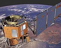
Greenbelt MD (SPX) Jul 15, 2005 Spring thaw in the Northern Hemisphere was monitored by a new set of eyes this year - an Earth-orbiting NASA spacecraft carrying a new version of software trained to recognize and distinguish snow, ice, and water from space. Using this software, the Space Technology 6 Autonomous Sciencecraft Experiment autonomously tracked changes in the cryosphere, the section of Earth that is frozen, and relayed the information and images back to scientists. The software, developed by engineers at NASA's Jet Propulsion Laboratory controls the Earth Observing-1 spacecraft. NASA's Goddard Space Flight Center manages the satellite. The software has taken more than 1,500 images of frozen lakes in Minnesota, Wisconsin, Quebec, Tibet and the Italian Alps, along with sea ice in Arctic and Antarctic bays. While other spacecraft only capture images when they receive explicit commands to do so, for the last year Earth Observing-1 has been making its own decisions. Based on general guidelines from scientists, the spacecraft automatically tracks events such as volcano eruptions, floods and ice formation. The most recent software upgrade allows the spacecraft to accurately recognize cryosphere changes such as ice melting. Previously, scientists spent several months developing software for Earth Observing-1 to detect changes in snow, water and ice. The new software is capable of learning by itself, and it took only a few hours for scientists to train it to recognize cryosphere changes. In fact, the new software has learned to classify the images so well that scientists plan to use it for the remainder of the mission. "This new software is capable of a rudimentary form of learning, much the way a child learns the names of new objects," said Dominic Mazzoni, the JPL computer scientist who developed the software. "Instead of programming the software using a complicated series of commands and mathematical equations, scientists play the role of a teacher, repeatedly showing the computer different images and giving feedback until it has correctly learned to tell them apart." On Earth Observing-1, the software searches for specific cryospheric events and reprograms the spacecraft to capture additional images of the event. "The software has exceeded all of our expectations," said Dr. Steve Chien, JPL principal investigator for the Autonomous Sciencecraft Experiment. "We have demonstrated that a spacecraft can operate autonomously, and the software has taken literally hundreds of images without ground intervention." Similar software has been used to distinguish between different types of clouds in images captured by JPL's Multi-angle Imaging SpectroRadiometer, an instrument on NASA's Terra spacecraft. Automatically identifying types of clouds from space will help scientists better understand Earth's global energy balance and predict future climate trends. Future versions of the software also might be used to track dust storms on Mars, search for ice volcanoes on Jupiter's moon Europa, and monitor activity on Jupiter's volcanically active moon Io. NASA's New Millennium Program developed both the satellite and the software. The program is responsible for testing new technologies in space. Community Email This Article Comment On This Article Related Links Autonomous Sciencecraft Experiment Earth Observing-1 SpaceDaily Search SpaceDaily Subscribe To SpaceDaily Express Earth Observation News - Suppiliers, Technology and Application
 New York NY (SPX) Jan 11, 2006
The importance of remotely sensed data and technologies to support natural disasters has prompted attention and action in Washington. New initiatives and legislation authorizing appropriations to the remote sensing industry will be discussed at Strategic Research Institute's U.S. Commercial Remote Sensing Industry conference, scheduled for February 9-10, 2006 in Washington D.C. |
|
| The content herein, unless otherwise known to be public domain, are Copyright 1995-2006 - SpaceDaily.AFP and UPI Wire Stories are copyright Agence France-Presse and United Press International. ESA PortalReports are copyright European Space Agency. All NASA sourced material is public domain. Additionalcopyrights may apply in whole or part to other bona fide parties. Advertising does not imply endorsement,agreement or approval of any opinions, statements or information provided by SpaceDaily on any Web page published or hosted by SpaceDaily. Privacy Statement |