|
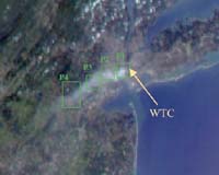
Pasadena CA (SPX) Sep 10, 2006 The collapse of the World Trade Center on September 11, 2001, and the fires that followed produced a noxious smoke plume, a complex mixture of tiny airborne particles and gases. Determining where humans may have been exposed to these contaminants and the amount of their exposure is very difficult. But recently, scientists from the Environmental and Occupational Health Science Institute Robert Wood Johnson Medical School and Rutgers University, in partnership with the Environmental Protection Agency and NASA's Jet Propulsion Laboratory have created a detailed numerical model that shows the pollutant dispersion from "Ground Zero" to the surrounding New York - New Jersey region. Air pollution in the urban atmosphere can damage human health, biological systems, and vegetation. A team of science assessment experts is using this new computer model to analyze the environmental and health impacts of this extreme event. For example, researchers are using model results in studies of the birth weights of infants whose mothers were near the World Trade Center on Sept. 11, 2001, when they were pregnant and of the incidence of asthma during the first weeks after the attack. The model helps them estimate human exposure levels based on where the plume was located, how much material it contained, and how long it remained. To map the path of the plume of pollution from the World Trade Center, the researchers used mathematical models of micrometeorological atmospheric circulation and tracer transport, surface measurements, and space-based observations from the high-resolution Landsat imager and the Multi-angle Imaging SpectroRadiometer (MISR) on NASA's Terra satellite. While some airborne material circulated within the urban "canyons," much of the material was lifted above the buildings and transported great distances. As a result, surface level exposures were not as frequent and intense as they could have been under different meteorological conditions. To simulate the transport of pollutants in the plume, the researchers had to understand its behavior on scales ranging from tens of meters to several hundred kilometers. They calculated atmospheric motions using a multi-grid regional atmospheric modeling system covering scales from 250 meters to 300 kilometers. To calculate pollutant transport, they used a hybrid particle and concentration transport model. They evaluated their model's simulated pollutant concentrations, transport, direction, and timing, by comparing the results with fine-scale aerosol measurements routinely acquired from the roofs of New York City public school buildings. The researchers calculated the evolution of the plume using a "Lagrangian" transport model, which considers the plume to be a collection of parcels that flow downwind. They found that for the model results to match the observations, the peak aerosol emissions in the World Trade Center fire must reach about 35 to 350 kg of particles per hour - thus, the concentration of aerosols within the core of the WTC plume was higher than the routine aerosol pollution in the world's most polluted cities. Since wind speed and direction can change dramatically at different levels in the atmosphere, knowing the height of the aerosol plume was a crucial part of ensuring that the model produced realistic results. JPL scientists used stereo images of the region acquired by the MISR instrument at about noon on September 12, 2001, combined with ground-based photographs of the plume, to determine the plume height. A natural color MISR image appears here (acquired by MISR's 70 forward-viewing camera on September 12) along with histograms of stereo-derived elevations at four points (P1, P2, P3, P4) progressing from the World Trade Center source to about 70 kilometers downwind. In addition to plume altitude and direction, MISR also provided information about plume evolution. Researchers could trace the plume's development by comparing the combination of airborne particles observed near the plume's source with particles that appear downwind in this MISR snapshot. The researchers also use MISR observations to check how well their model estimates the amount of particulate material the plume contained. The scientists published their findings in the July issue of the journal Environmental Fluid Mechanics. Community Email This Article Comment On This Article Related Links Making money out of watching earth from space today Robert Wood Johnson Medical School Rutgers University Earth Observation News - Suppiliers, Technology and Application
 Sao Jose dos Campos, Brazil (SPX) Sep 08, 2006
The Brazilian National Institute for Space Research (INPE) has placed a contract for a second year with DMC International Imaging to acquire high-resolution satellite images of the entire 5 million square kilometres of the Amazon rainforest. In 2005 DMC rapidly acquired images of the whole Amazon Basin in 6 weeks to provide Brazil with vital information for the annual programme to monitor deforestation and combat illegal logging. The programme is now repeated in 2006. |
|
| The content herein, unless otherwise known to be public domain, are Copyright 1995-2006 - SpaceDaily.AFP and UPI Wire Stories are copyright Agence France-Presse and United Press International. ESA PortalReports are copyright European Space Agency. All NASA sourced material is public domain. Additionalcopyrights may apply in whole or part to other bona fide parties. Advertising does not imply endorsement,agreement or approval of any opinions, statements or information provided by SpaceDaily on any Web page published or hosted by SpaceDaily. Privacy Statement |